
NW5 is Kentish Town. Probably nothing to do with Kent but maybe named after a man called Kentish. In researching NW5 I discovered that the river Fleet runs right through the postcode. The Fleet is one the “lost” rivers of London as it is almost entirely hidden from view from its start on Hampstead Heath to its end by Blackfriars Bridge. But as we shall see there is one place in NW5 where you get a glimpse of where it flows even if you cannot see the water!
We start our walk at the Post Office, at 212 – 216 Kentish Town Road, just along from the station on the same side of the road. Turn left out of the Post Office and take the first turning on the left (Patshull Road), then do a right and a left which takes you into Lawford Road. Go almost to the end.
Stop 1: Number 50 Lawford Road
Our first stop is on the right and was home to writer George Orwell (1903-1950)
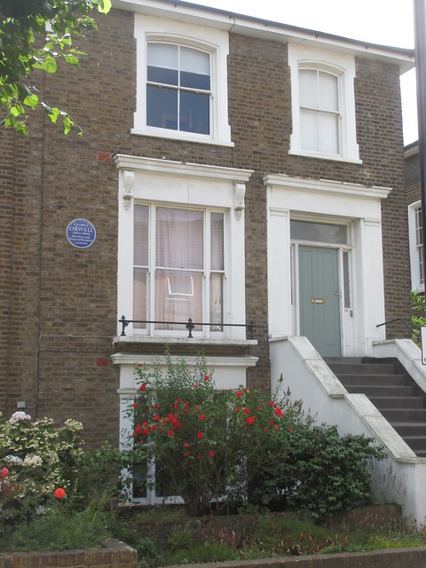
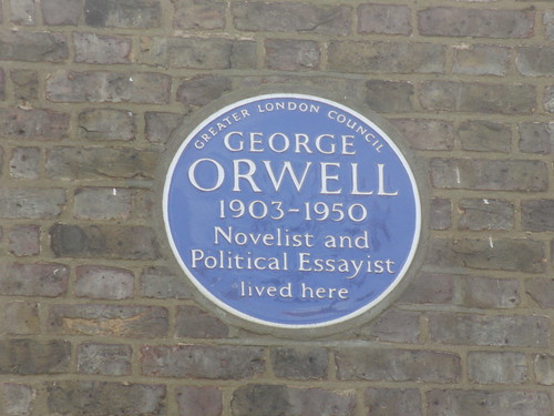
We have already seen one blue plaque to him in on Portobello Road W11 – and according to http://openplaques.org/people/183 there are actually some 9 different plaques to Orwell, not all blue, across Greater London. I think he lived here in a flat in 1935/36, which was the time he was working at a second hand book store in Hampstead called Booklovers’ Corner.
Now retrace your steps along Lawford Road. At the end turn left and follow Bartholomew Villas which then mutates into Bartholomew Road. Just follow the road round until you get back to Kentish Town Road.
As we were so close I had to include this even though it is technically in NW1 – just. If you turn left on the main road and go a little way to the junction, you will see ahead of you on the right a familiar style of building.
(If you want to be purist and stay in NW5 turn right and pick up at stop 2 just after Prince of Wales Road on your left.)
Stop 1a: site of former South Kentish Town station
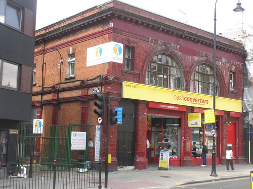
This has the tell tale signs of a Leslie Green design Underground station and indeed it is. This is the former South Kentish Town station. This was going to be called Castle Road but this was changed just before the station opened in 1907. The station was temporarily closed following strike action at the Lots Road power station on 5 June 1924. But it never re-opened apparently due to the very low number of people using the station. So today it is just a ghost station, although unlike the one we saw in NW3 this one actually was open for a while.
Retrace your steps along Kentish Town Road. Our next stop is just past Prince of Wales Road on the left.
Stop 2: site of Palace/Gaumont cinema
Now this unpromising looking building was once where the Kentish Town Palace cinema (later the Gaumont) stood.
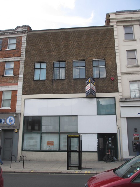
The Palace Cinema opened in December 1913 and was designed by John Stanley Beard, who went on to design many cinemas in the London area. Provincial Cinematograph Theatres took it over in 1920 and they were bought out by Gaumont British Cinemas in February 1929.. It was re-named the Gaumont in 1948 and finally closed in April 1959.
Part of the building was demolished and the Kentish Town Road facade was destroyed. But a bit of the original building survives around the corner in Prince of Wales Road. This is now used as a Law Centre.

Keep walking along Kentish Town Road (back towards where you started)
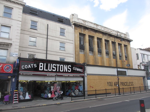
Stop 3: Blustons store
Now this is quite an amazing survival – one of those old fashioned Ladies’ wear shops designed for window shopping, with what I would guess is a 1930s shop front.
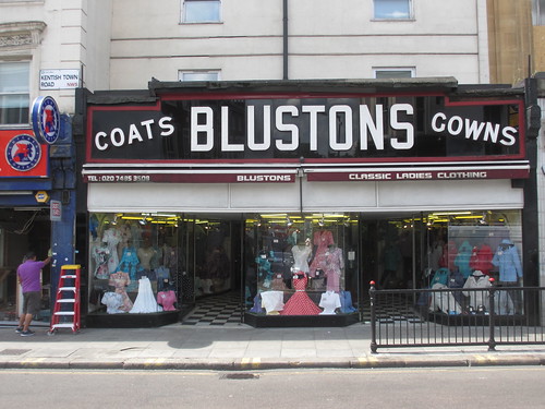
Nowadays everything is on display and you chose things, maybe try them on and then go and pay for them. But it did not used to be like that. Once most of the stock was kept in drawers or display cabinets and you had to be “served”. And the person serving you was probably on commission so had a vested interest in making a sale. If you wanted to see what goods in the shop but did not want to run the gauntlet of the sales people, then you would look in the shop windows.
Which is why some shops started to have very extensive windows displays which went quite deep into the shop and the Blustons store here in Kentish Town is a rare survivor of that style of shop.
Just looking at the various buildings along here, this is another street that used to be a much more extensive shopping area but which has lost all its big stores. The one next to Blustons looks like it was a major store, but I have not been able to find out what it was.
Interesting that whilst it is relatively easy to find out about an old cinema or theatre building, or a railway station, it is surprisingly hard to get consistent information about former shop businesses beyond the bare fact that such and such a shop was at a certain address.
Moving on, I should just point out in passing the side street Anglers Lane

This apparently is a little reminder that the River Fleet flowed hereabouts, although there is no sign on the surface now.
Fascinating fact: Angler Lane was once home to the world’s largest false teeth factory (thanks to my fellow Footprints of London guide Rob Smith for that gem – he by the way is one of a number of guides who from time to time get together and do an all day walk following the lost river Fleet – costs £18 (£13.50 concession). Bookable through http://footprintsoflondon.com/guides/rob-smith)
Continue walking along Kentish Town Road and soon on the right is the station
Stop 4: Kentish Town Station
There are actually two stations here – the very visible Underground station and the less visible national rail station.
First the Underground station, which is another Leslie Green design. It dates from 1907 but interestingly today has escalators rather than lifts. As the first regular escalator on the Underground was put in at Earls Court in 1911, Kentish Town station must have been rebuilt at some point probably in the 1920s but I cannot seem to find out exactly when.

But the first station here was opened by the Midland Railway in 1868 on the extension to its new London terminal at St Pancras. This surface station was rebuilt in 1983 and nothing of the original station building remains at street level. There is just this odd looking canopy. The tracks go under the road here and on the other side there is a gaping hole in the street scene where the bridge parapet is, but you cannot actually see down to the tracks. Makes for a less than satisfactory street scene.

Now beyond the railway take the left hand pavement and soon on the left is our next stop
Stop 5: The Forum
This building was constructed as a cinema in 1934 and was of a very similar in design to the Forum in Ealing, W5 which as we saw remains just as a facade awaiting redevelopment.

The Kentish Town Forum seated almost 2,200 people on two levels. The architect was one John Stanley Beard who had earlier built the Palace down the road but the interior design was by W.R. Bennett. It was taken over by ABC in 1935, although it was only renamed the ABC in 1963.
It was closed in 1970, and so as far as I can discover it was never subdivided. It became a bingo hall then a dance hall and finally a rock venue. At one point it was called the Town and Country Club but it reverted to its original name in 1993.
Now cross the road and go down the side street – Fortess Walk
Just thought it worth mentioning in passing when I was there, there were a number of posters along the ground floor of the building on the right, one of which was this Parliament Hill Lido poster
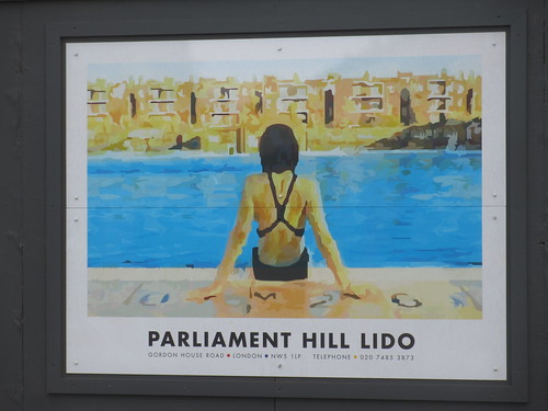
We will come to this in the real world in due course.
At the end of Fortess Walk turn left into Fortess Road and go along this road until you reach Number 50
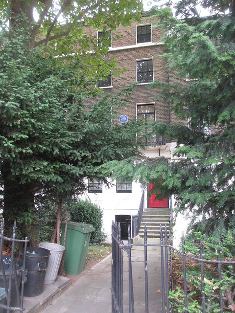
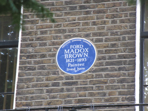
Stop 6: Number 56 Fortess Road
Here hidden behind extensive greenery is a blue plaque to Ford Madox Brown (1821-1893). He is often bracketed with Pre-Raphaelite painters, though he was never actually a member of the Pre-Raphaelite Brotherhood itself. However his style was close to that of William Holman Hunt and John Everett Millais. Quite a few of his pictures are owned by the Tate.
Continue along Kentish Town Road and turn left into Lady Somerset Road, then turn right into Burghley Road. Where this sweeps to the right, there is a turning on the left (Ingestre Road) go along this and ahead you will see a strange looking footbridge
Stop 7: Footbridge (and pipe) over railway
This is an intriguing bridge. First it starts off at one level and then suddenly after a while it goes up some steps
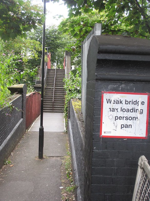
The reason is that we are crossing two railway lines which are at different levels.
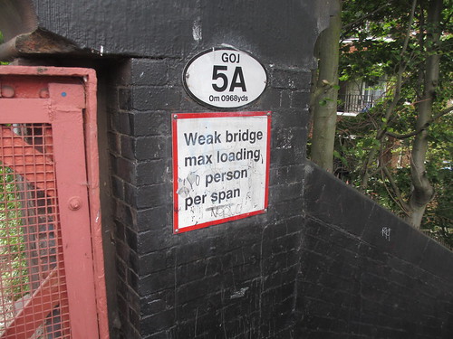
Note the unusual sign suggesting that there should be a limit on the number of people crossing the bridge.Sadly the sign has been vandalised so we cannot see just how many people can safely cross!
But what is perhaps more interesting is that rusty looking pipe to the left of the footbridge. (in case you are wondering the picture was taken looking back so the pipe is on the right!)
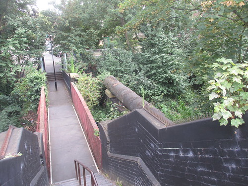
This pipe contains the River Fleet and is just about all you can see of the river Fleet in NW5. So that is your fleeting glimpse.
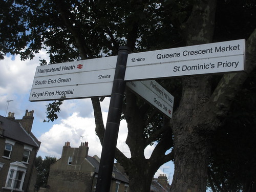
Once over the footbridge, turn left and follow the road as it turns right. This is now York Rise and the River Fleet runs entombed beneath the road. Take the first left (Chetwynd road and go to the end, where you turn left into Highgate Road. Our next stop is just ahead across on the right hand side of the road
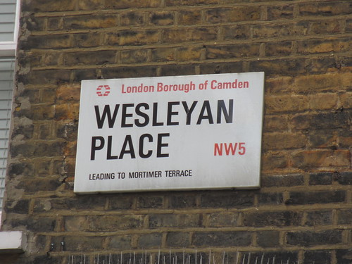
Stop 8: Weslyan Place
It has been suggested that John Wesley preached in the area, possibly at the Gospel Oak which we will come to at the end. But this little street is apparently named Weslyan Place because there was an early Methodist chapel here.
Now whilst we are here I have to point out this little pub – the Southampton Arms. Looks old fashioned but one wonders how hard they have tried to make it look like this! But don’t you just love the sign on the side. Strange combination isn’t it!

Now return along Highgate Road, past the junction with traffic lights and past a little garden on your left. Take the turning on your left at the end of the garden.
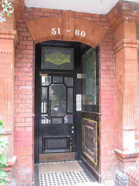
Stop 9: Parliament Hill Mansions, Lissenden Gardens
The street is called Lissenden Gardens but is in fact dominated by a mansion flats development called Parliament Hill Mansions. Walk along the street until your reach a junction. Straight ahead is the block which contains Number 52, which was where the poet John Betjeman was born.
There is a great article about JB and his Kentish Town connection in the local site Kentishtowner. This includes his poem called Parliament Hill Fields in which he describes a local tram journey. This article also has a 1971 letter which has some evocative descriptions of what was even then a long lost Kentish Town. This has tantalising references to long forgotten shops in Kentish town – many of which were along the route we took at the start of today’s walk.
Take the left way and go to the end and turn right. The entrance to our next stop is almost immediately on our right.
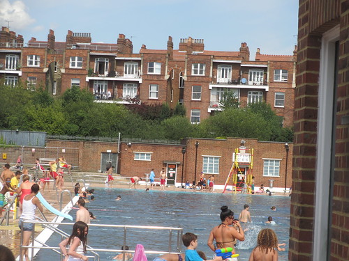
Stop 10: Parliament Hill Lido
We saw the poster of the Lido earlier. Now here is the real thing.
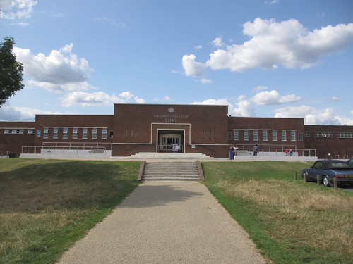
Opened in August 1938, this one one of a number of lidos built by the London County Council and it is nearly identical in design to the ones on Victoria Park and Brockwell Park. It is unheated but nevertheless operates in the winter for morning swims – brrr!
The Lido is a bit like a fortress and so you have to pay to see inside. However I did find a little place at the side where you could get a “fleeting glimpse” of the inside. In the background is Parliament Hill Mansions which we saw at the last stop.
Return to the main road. Turn right and go under the railway past Gospel Oak station. Take the first left and then the first right (Lamble Street). Do have a look at the lovely little villas of Oak Village as you pass. Ahead you will see a pedestrianised area. This is our next stop.
Stop 11: Lismore Circus
What a curious 1970s development. According to Pevsner, this area was once a Victorian suburb planned in the 1870s with the streets radiating in six directions from the Circus. The houses are all gone and all that survives from the 19th century is the long wall of the Midland Railway ‘s cutting which early on disturbed the original plan for a quality suburb.

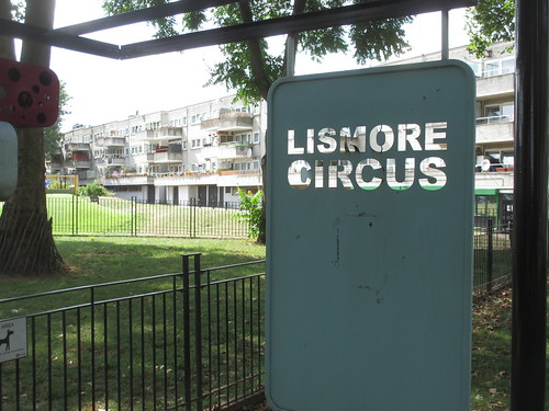
It is all very sad. The 1970s redevelopment did not come out quite as planned. There was supposed to be shopping parade here, but the decision was to retain the nearby Victorian Queen’s Crescent shops and so the full complement of shops was not built. Probably the right decision, as it left some character but it did mean this replacement for the original circus lost its planned purpose.
Here by the way is the wall with the railway on other side. Strange at first glance you do not realise there are multiple train tracks down there but then every so often you here a train.

Perhaps here I should quote a little bit from Betjeman’s 1960 autobiographical work “Summoned by Bells”:
“Here from my eyrie, as the sun went down,
I heard the old North London puff and shunt,
Glad that I did not live in Gospel Oak.”
(before any railway purist complain, I know that we are not by the North London Railway just here – that lies slightly further to the north! But clearly it shows that Gospel Oak was not very high up the pecking order)
Walk along the grey block with the shops (such as they are). At the end you will reach Southampton Road. Turn right and go the junction with traffic lights.
Stop 12: possible site of the Gospel Oak
It is said that this is the location of the original Gospel Oak, which was a tree where there was the preaching of the Gospel. And this of course gave this part of NW5 its name.
There is an interesting article here also from the Kentishtowner http://www.kentishtowner.co.uk/2012/03/14/wednesday-picture-where-the-hell-is-the-gospel-oak/
This has a nice postscript about local resident Michael Palin who in 1998 attempted ceremonially to plant a ‘Gospel Oak’ on the fringes of nearby Lismore Circus. Sadly the tree has not survived.
And so we are at the end of our NW5 walk, and we have virtually run out of NW5.
But I should just one little thing over the border in NW3 which you can see from stop 12.
Look across the road and you will the street is called Fleet Road
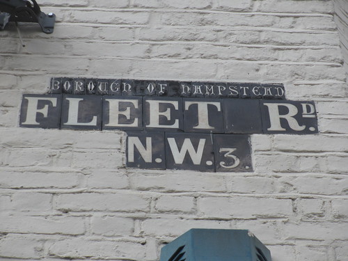
This is the western arm of the Fleet which rises in Hampstead Heath. This joins the eastern arm which we saw in the pipe, down in Camden Town.
So this really is the end of our NW5 walk. We followed the Fleet upstream but could only get that little glimpse.
There are a few buses here, perhaps the most useful for onward travel is the Number 24, which goes down into Camden Town and right through central London to Victoria and Pimlico. But if you want a train you can walk from this junction along Mansfield Road to Gospel Oak on the Overground.
