
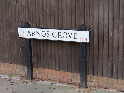
N14 is actually Southgate. We have already been to New Southgate (N11) and Palmers Green (N13) where Southgate Town Hall is, but now we get to Southgate proper. It is by the way called Southgate because it was the location of the south gate of Enfield Chase, once a royal hunting ground. Southgate was administratively part of Edmonton until 1881 when it got its own local board. this became an Urban District Council in 1894 and got municipal borough status in 1933.
There is a lovely little snippet of British Pathe news with the title “Ex Glande Quercus – from acorn to oak” showing the future King George VI present the charter of incorpration for the new Municipal Borough of Southgate (or Southgit as he calls it) in October 1933.
http://www.britishpathe.com/video/ex-glande-quercus-from-acorn-to-oak
I know it is a bit of a cheat as the ceremony probably took place at the Town Hall which is actually in N13, but it gives us the title for our N14 walk, and in fact we get to see a rather old oak later, so that kind of justifies the title. Note also the Pathe news mention of Lord Inverforth, who was unavoidably absent. We will hear a bit about him later too.
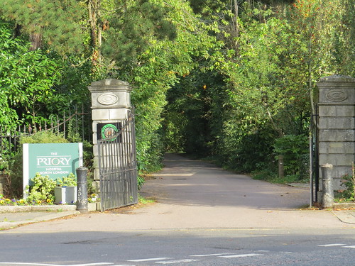
So we start our walk at the Post Office at 64 Chase Side which is in the main shopping centre of Southgate. Turn left out of the Post Office and soon you will see on your right the station with its circular ticket hall surrounded by a brick crescent with shops and bus stops. This is our first stop.
Stop 1: Southgate Underground station
This is another wonderful Holden station, opened in 1932 on the northern extension of the Piccadilly line.

It has a wonderful ticket hall and do go down to the platforms if you can because it still has the old style uplighters on the escalators and some nice lights and tile finishes at platform level.

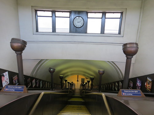

Back on the surface you do get the feel this is an alien space craft just landed. But I have to say I do not think this ranks as the greatest Holden station. It could do with a tower maybe. And the crescent of shops around the ticket hall is strangely forbidding with that blank first floor wall.
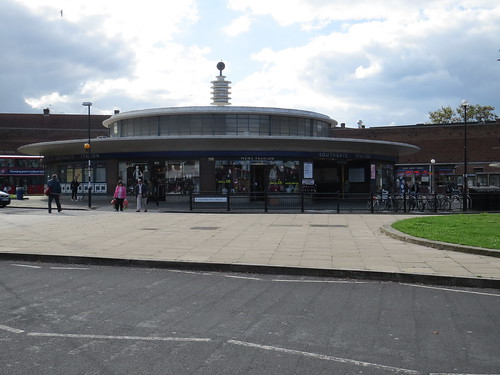
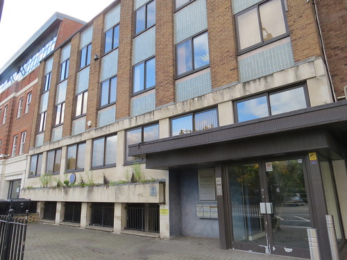
Now if you look across the roundabout from the station you will see a modern block to the left and an older row of shops to the right. Follow the row of shops to the right and you are at the start of the street called The Bourne. Just at the end of the shops is a modernish office block which is our next stop.
Stop 2: Hobart House
If you have read one or two of my posts, you will guess that if we stop at a dull looking office block, then usually this is built on the site of a theatre or cinema.
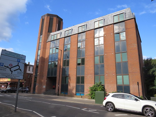
And indeed this rather uninspiring building called Hobart House was the site of a cinema.
It opened in October 1935 and was operated by Oscar Deutsch’s Odeon Theatres Ltd. It was taken over by Odeon during construction, which may account for the rather unusual choice of architect – Bertie Crewe, who was better known for his theatres rather than for cinemas. It had a stage and dressing rooms, as well as the usual cafe/restaurant, plus a car park.
The Odeon closed in September 1972 and remained unused for over three years until it was leased by an independent operator Windsor Entertainments. They re-opened it on 26 December 1975 as the Capitol Cinema, using initially only the stalls area. But it was not to last and it closed for good in January 1981. The building lay empty again. But despite some efforts by locals to find a new use that did not happen and the building was demolished in September 1982 when this office block was built.
Curiously there is a little plaque to remind us of the former cinema.
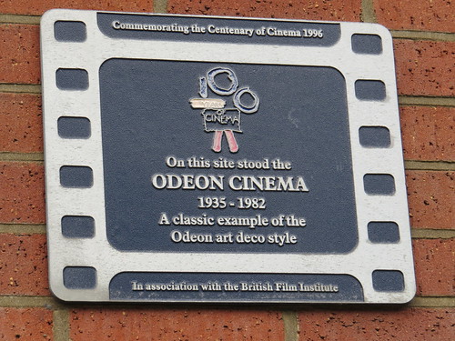
Strange to commemorate the centenary of cinema by putting a plaque to remind us of a building which is no longer there when they could have found an actual Odeon that was still standing.
Continue walking along The Bourne and at the corner of Queen Elizabeth Drive is a driveway.
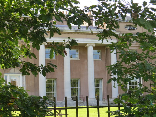
Stop 3: Grovelands House and Park
This driveway leads to Grovelands House, one of the many large houses that were once in this area.
We will see the house in due course, but first for the public park which used to be the grounds of the house. Southgate Council bought the land in 1913 to create the park. Keep walking along The Bourne and eventually on the left you will see a gate with an arch over it.
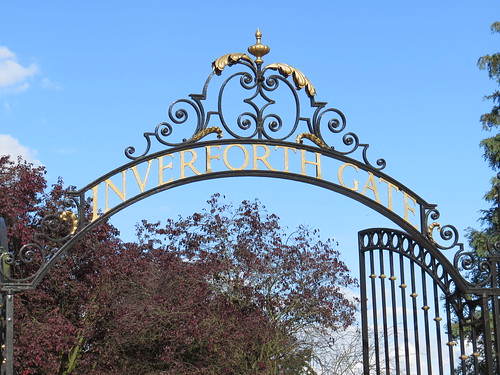
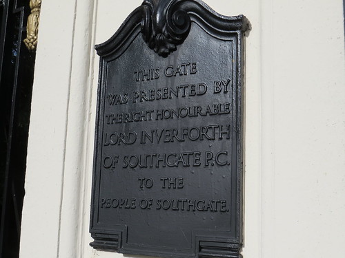
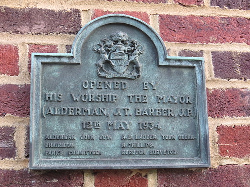
This is the Inverforth Gate, so called because Lord Inverforth gave it to the Southgate Urban District Council in 1925 as can be seen from the pair of plaques.

Andrew Weir, Lord Inverforth (1865 – 1955) was originally from Scotland and made his money in shipping. He advised the government on shipping during the First World War. He was made a peer in 1919 and was the Minister of Munitions between 1919 and 1921. He widened his business interests including becoming involved in Marconi and being a director for Lloyds Bank. He continued working into his 91st year.
In the 1920s and 1930s he had a strong connection to Southgate and was responsible not only for this arch but also for the purchase of the land that is now Arnos Park (which we saw in N11).
There is another connection with something we have already seen. He lived out his last years in Hampstead, in a house which he renamed Inverforth House. We briefly saw this in our NW3 walk, as it was previously the house occupied by William Lever, Lord Leverhulme and has a blue plaque to him. Lord Inverforth does not seem to have his own plaque anywhere.
Go through the gate and walk along the main path ahead of you.
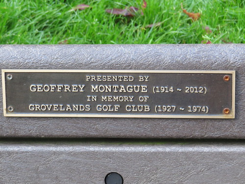
And now for a little curiosity. I often look at park benches to see if there is any interesting story to learn from the little plaques that may be attached.
Here as we enter Grovelands Park, just on the left of the main path is a dedication I have never seen before. It is in memory of a golf club!
Keep walking along the main path keeping the perimeter to your left. Soon you will see Grovelands House, initially just glimpses through the trees but you will get a better view as you walk on..
The house was built in 1797 by John Nash for a man called Walker Gray who was, according to architectural historian Pevsner, a brandy merchant related to the Walkers of Arnos Grove (more of whom anon).
The House was extended by John Donnithorne Walker, also one of the Taylor Walker brewing family. He is said to have dislike seeing other men’s chimneys, hence the park.
It was owned by the family until 1921 although it was used as a hospital from 1916. And it was a hospital up to 1977, and after a few years of neglect was reopened as a private clinic. Today it is a branch of the famous Priory Clinic as the eagle eyed may have noticed from the sign at the entrance gate.
If you keep walking you will get quite a good view of the house.
Now you have a choice of either walking back the way you came or else keep walking until you reach an exit on your right which takes you out to the junction of Queen Elizabeth Drive and Wychgate. You can take either of these roads (going to the left as you exit the park), as they will both take you back to The Bourne and the site of the Odeon.
Carry on back to the roundabout by the station and take the main road coming out to the left (which is High Street).
Our next stop is just a little way along on the right on this modern office building called Mountview House.
Stop 4: Site of the Village Hall, 154 High Street
Now here is a curious blue plaque placed by Enfield Borough Council.

Not sure why this particular parish hall site should warrant a blue plaque!
Keep walking along the High Street, and after a while you will get to what might be called Old Southgate (but is not)
Stop 5: Number 40, The Green

This has another Enfield plaque, showing that this elegant little terraced house was the seat of the first local Government in Southgate

Again an odd thing to commemorate. Perhaps someone in Enfield Council was particularly obsessed by the history of the administration of Southgate.
Continue walking along The Green and you see an old blue plaque which is here for more understandable reasons.
Stop 6: Number 33, The Green
This 20th century building has a little blue plaque to commemorate what was here before.
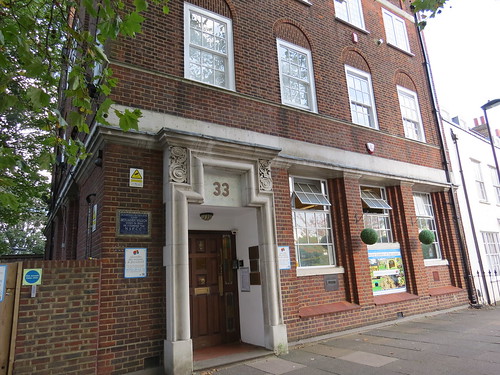
And this shows this was the location of the home of Benjamin Waugh founder of the National Society for the Prevention of Cruelty to Children (NSPCC).

Benjamin Waugh (1839 – 1908) was a congregationalist Minister, social reformer and campaigner. In 1884, he founded the London Society for the Prevention of Cruelty to Children, with veteran social reformer Earl Shaftesbury as the first chairman. It evolved to become the NSPCC some five years later (1889), with Waugh as its first director. So technically the plaque is not quite correct.
The NSPCC was granted its Royal Charter in 1895, when Queen Victoria became its first Royal Patron. But it did not change its title to “Royal Society for the Prevention of Cruelty to Children” or similar, as the name NSPCC was already well established, and to avoid confusion with the RSPCA. Interestingly the RSPCA got its Royal Charter in 1840, so the idea that Britons love animals more than children may be not such a new thing.
Keep walking along The Green to the next row of houses
Stop 7: Numbers 23 – 31 The Green

This rather lovely row of houses dates originally from the 18th century. Pevsner says they were built by local landowner Richard Goad in 1777 on charity land, apparently for almhouses. It says that south London architect Michael Searles made survey plans but whether he designed the houses is uncertain. It then goes on to say they were heavily reconstructed in 1981.
But the plaque has a slightly different story.

It says they were built 1780 by the Valentine Poole trust for the poor of Barnet. The architect was Michael Searles (1750 – 1813) and they were saved from demolition by the Southgate Civic Trust and reconstructed in 1981 by Peake Estates limited. Interesting difference of emphasis.
Continue along The Green past the Olde Cherry Tree pub which Pevsner pointedly says is “not all old”. Go along the row of shops and cross over the main road. Our next stop is just across the way.
Stop 8: Southgate Beaumont (Arnos Grove house)
Peek in the first roadway entrance to see the north side of this extensive building, then walk a little further along and go in the next road entrance where you can get a better view of the east front of the building. This was the house known as Arnos Grove and this side of the building contains the original 1720s house.
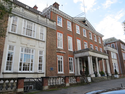
The estate was owned from 1777 to 1918 by Walkers of the Taylor Walker brewing family (including the Walkers of Southgate), who bought the nearby Minchenden estate to increase the area of Arnos Grove to over 300 acres. The estate was then purchased from the last of the Walker brothers by Lord Inverforth who sold the southernmost 44 acres to the Southgate Urban District Council. The Council then created Arnos Park in 1928 (which we saw in N11).
The Arnos Grove mansion was also sold in 1928 to the North Metropolitan Electricity Supply Company. The mansion was subsequently enlarged and encased in red brick – it is now a residential care home called Southgate Beaumont.
Note there is a blue plaque on the wall.

This says “here lived the Walkers of Southgate, seven brothers. All famous in 19th century cricket.” We will hear a bit more about the cricketing connection at our last stop.
Now return back to The Green and keep to the left. you will cross a wide street which is called Arnos Grove because it is built on the land from the estate.
Confusingly we are in N14 whereas Arnos Grove station and the area people think of as Arnos Grove is further south and in N11.
Go past the church (Christ Church by Sir George Gilbert Scott, worth a visit if it is open). Keep going until you see a little black metal gate on the left. Go in there.
Stop 9: Minchenden Oak Garden

This rather sad little park was created by the council in 1934 around an old oak tree.
Various claims have been made that this is the largest and/or the oldest Oak in England. It may be as old as 800 years and at one time it may have had the largest canopy but sadly no longer, as it has been somewhat pruned.

The garden has had some work done but more needs to be achieved. The Gardens (and Oak) have some friends who are working on improving the surroundings. Here is a link to the Friends website and there are some pictures of a rededication in May this year involving the Bishop of London and the planting of a sapling grown from one of the acorns from this tree.
You can even buy a commemorative mug for £5 with the words:
Its great trunk rooted in history
Its leaves bathed in the memory
of 800 summers
are in themselves
The Remembrance of Things Past
Go out of the garden and turn left. Just a little way along (and across the road) is the entrance to our next stop.
Stop 10: Walker Cricket Ground.
So now we get to the Walker Cricket Ground. This was founded by John Walker (1826 – 1885), the eldest of seven cricket playing brothers and four (presumably non cricketing) sisters, who lived at Arnos Grove.

Here is a link to the Walker Cricket club website which explains some of the history http://www.thewalkerground.co.uk/history.html
The Walker brothers were all first class cricketers and were behind the creation of a cricket team in Middlesex in 1859, for founding Middlesex County Cricket Club in 1864 and for establishing Middlesex County Cricket Club’s home at Lord’s in 1877. Confusingly, Lord’s is owned by the Marylebone Cricket Club which although it has the same initials is a quite separate organisation from the team which has its home there, the Middlesex County Cricket Club.
And as you can see The Walker ground in Southgate is home to a number to other things, all with the same style signs, courtesy of Griffin Signs, who get a little advert in.
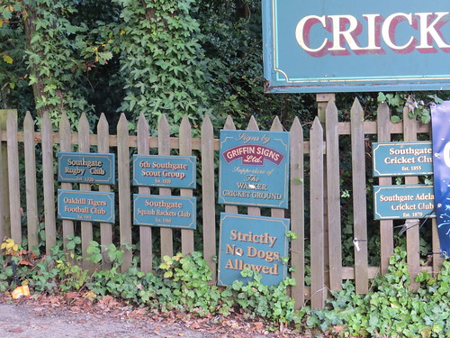
You can have a little look at the “famous” turf.
But to be honest there is not much to see.
So we have now reached the end of our N14 walk. From Waterfall Road you can get a 298 bus either to Arnos Grove or Southgate stations (but it is quite a walk to find a bus stop). So you might as well go back to The Green where you can get a bus back to Southgate (W6, 121, 298 or 299) or alternatively to Palmers Green (W6 or 121).

Thanks for all the interesting information, Stephen.
One correction, though. The “Ex-glande-cuercus” film shows the Charter of Incorporation being presented by George, Duke of Kent, fourth son of King George V. If you remember, Prince Albert, Duke of York and subsequently George VI, had a pretty bad stammer in his youth, so I’m guessing he would have avoided making public speeches unless absolutely necessary.
Hi Stephen. I really enjoy your walks, (admittedly, normally from the comfort of an armchair!); but wonder if you are wedded to the idea of not crossing post code boundaries? I ask because last year my wife and I ( and Polly the Cocker Spaniel) joined a local (Wood Green/Tottenham) group which from time to time organises a walk that traces the course of the river (or rivulet?) Moselle, from its source in Muswell Hill (N10) through Tottenham, (largely N17) to the point where it discharges into the River Lee (not at all sure of that postcode!) The Moselle is largely underground, but there is a stretch of the river that flows overground through Lordship Rec., and then disappears under the Broadwater Farm estate, and it reappears with it’s sister stream the Lesser Moselle, in Tottenham Cemetery. Despite it being a largely invisible stream, it has left lots of clues to it’s once more visible self in street names, the names of houses and the structure of old bridges etc. The park where it discharges (I have forgotten the name of the park, but I can find that easily enough if you are interested,) has a beautiful old [working!] steam pump adjacent to the River Lee. The remodeling of Lordship Rec. section into a series of water meadows is alone worth a visit. It is a beautifully picturesque walk, which surprises most people who think of Tottenham as a dour inner city borough.
The name “Moselle” (which I always thought was a bit of a joke for a muddy stream, based – I assumed – on the European River of that name;) turns out to be a corruption of “Mossy Well” which is also the origin of Muswell Hill. I would be happy to do some research for the walk, and accompany you on it if you ever decide to break the post code habit!
All the best! Francis.
Thanks for your comments, Francis. I think straying over the post code boundaries would rather undermine the concept! As to the Moselle, one of my Footprints of London colleagues (Jen Pedler) has already researched and led a walk following that river. She did it as a bit of a joke for the River walks Festival we did earlier this year. But this was a great success and Jen had a sell out walk. Sadly I could not join her but a highlight was apparently the signing of a 400 year old folk song “The Tottenham Toad”. Here is a link to the blog on the River festival which explains about the song amongst other info on the River walks. http://footprintsoflondon.com/2015/05/river-walks-festival/