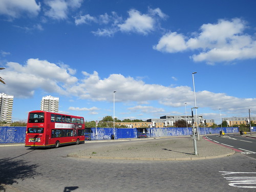
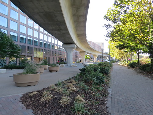
E16 is Victoria Docks and North Woolwich and I have to say this postcode is quite unlike any other I have visited. It is a strange mix of industrial dereliction and modernity. Even though there has been a lot of building going on, much of it is still rather a wasteland.
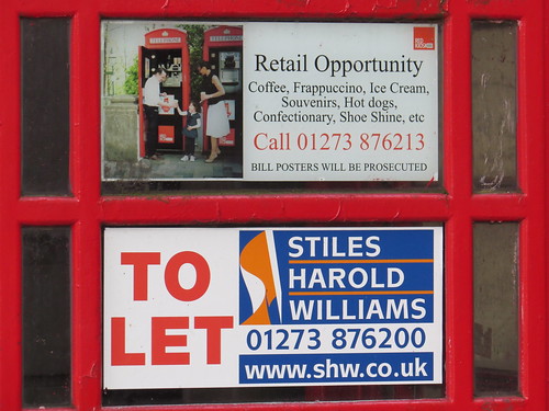
We start our walk at the North Woolwich Post Office which is at 17 Pier Road, E16. This is just along the road from King George V Docklands Light Railway (DLR) station. Turn right out of the Post Office and go over the cross roads. Head towards the Woolwich Ferry. Our first stop is just on the left.
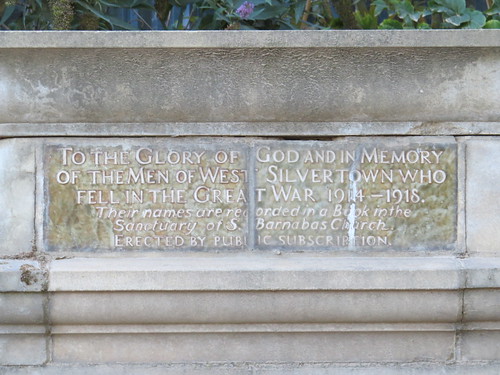
Stop 1: Royal Victoria Gardens
The area is a bit run down but suddenly – and rather unexpectedly – you come across a proper little park with grass and trees. This is Royal Victoria Gardens.

According to the London Gardens Online site:
“Royal Victoria Gardens were opened by the LCC in 1890 on land acquired with funds raised through public subscription. The former marshland had been acquired by George Bidder’s North Woolwich Land Company in the 1840s and was rapidly developed for industrial use, encouraged by new rail and ferry links. In 1850 the proprietor of the Pavilion Hotel expanded his hotel and laid out tea gardens, which he opened in 1851 as the Royal Pavilion Pleasure Gardens. Crowds of visitors were attracted to its numerous entertainments but in the early 1880s it began to make a loss, but the site was saved from development. The public gardens were completely redesigned, with little remaining of the pleasure gardens apart from the riverside terraces and central walk. There were a series of cells of a different character or activity, and a bandstand in the centre of the southern terrace. The Gardens suffered bomb damage during 1940 and little of the Victorian layout remains today.”
There is more about these gardens on the attached link: http://www.londongardensonline.org.uk/gardens-online-record.asp?ID=NEW027
Now you will see a concrete ramp close to the entrance. Go up here. This leads onto the riverside walk.
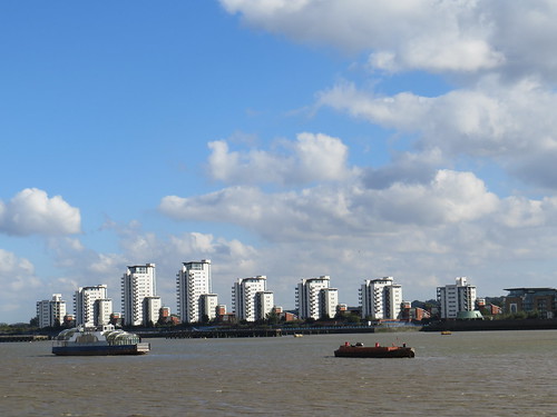
From the riverside walk you have a great view over to new developments on the other side of the river to the east of Woolwich.
And go to the right and you will see another concrete walk way with our next stop peeking up beyond the flood wall.

Go up these steps and view the building over the road.
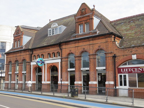
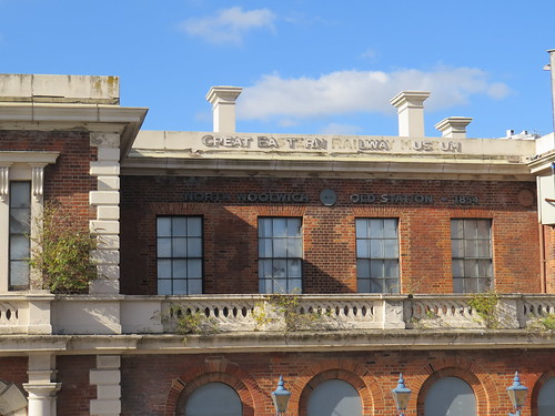
Stop 2: Former North Woolwich Station
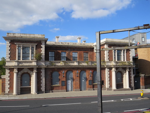
This was once North Woolwich station. And if you look closely you will also see the words (or at least many of the letters of the words) “Great Eastern Railway Museum”
The station first opened in June 1847 at the southern end of the Eastern Counties and Thames Junction Railway from Stratford.
The route became an extension of the North London Line in 1979 and the line was electrified in 1984. But this end of the line became in effect a single track. The original station building here ceased to be used and was replaced by something rather more basic just along the way.
The station and the line to Stratford closed in December 2006 to allow for conversion of the North London Line between Stratford and Canning Town to become part of the DLR. But the far end of the line through Silvertown to North Woolwich did not become part of the DLR and so was abandoned – though we shall see much of it (but not this far end) is going to get a new lease of life. The area was not left isolated as it was served by King George V DLR station which opened in December 2005.
For over twenty years (from 1984 to 2008), the original North Woolwich station buildings and one disused platform became the North Woolwich Old Station Museum which was dedicated to the history of the Great Eastern Railway.
But as we can see this too is no longer. Here is what the Great Eastern Railway Society had to say about the closure:
“The Society regrets that the North Woolwich Old Station Museum closed at the end of November 2008.
Although the Great Eastern Railway Society had a significant interest in the Museum, and had contributed much to its opening and some of its displays it had no involvement in the Museum’s management. This was in the hands of the London Borough of Newham who, unfortunately, were no longer in a position to financially support the facility.
The contents of the Museum have not been moved together, but have been dispersed to various other locations:
* Some items have been returned to their owners who had placed them there on loan.
* The bulk of the smaller artefacts have gone to the East Anglian Railway Museum at Chappel.
* The GER horse-drawn parcels lorry has gone to Mangapps Railway Museum at Burnham-on-Crouch.
* Many documents have passed to the GERS and have been placed on loan and deposited at the Essex Record Office at Chelmsford.”
Kind of sad that this did not survive, but perhaps there were just not enough people interested in the Great Eastern Railway to justify it having a dedicated museum.
Now turn and look over towards the river for our next stop.
Stop 3: Woolwich Ferry
The Woolwich Ferry is a strange kind of relic that ought not to be here in the year 2016.

There has been a ferry operating in Woolwich since at least the 14th century, and commercial crossings operated intermittently until the mid 19th century.
Today’s ferry operates as a free service under an 1885 Act of Parliament. Originally the service was operated by paddle steamers. New vessels came into use in 1923 and these in turn were replaced in 1963 by the present fleet of “Roll On Roll Off” ferries.
The three boats are named after prominent London politicians of the past:
*John Burns (1858 – 1943) – a Liberal politician who was at one time MP for Battersea.
*Ernest Bevin (1881 – 1951) a Labour politician who at the time of his death was MP for Woolwich East
* James Newman who was Mayor of Woolwich from 1923 to 1925.
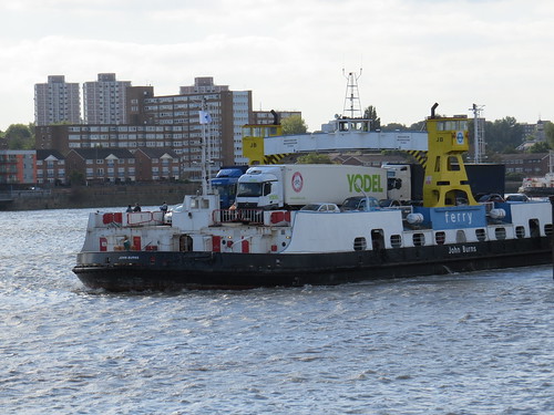

Normally the service is operated by two boats and in recent years they have carried around 20,000 vehicles a week. This translates to about 2 million people when you count vehicle passengers and the odd traveller on foot.
The Woolwich Ferry is where the South and North Circular Roads meet in the east. The continued existence of a ferry here is because of the inability of successive Governments (national and local) to address the issue of building more road crossings across the Thames in the east of London.
Additional links such as the Thames Gateway Bridge and the Gallions Reach Crossing have been proposed as replacements, but the schemes have come and gone and nothing has been built. So there are no immediate plans to discontinue the Woolwich Ferry as long as there is a demand. But given the boats are now well over 50 years old, I guess there must come a time when a decision has to be taken to replace them or withdraw the service.
Interestingly Tolls cannot be levied on the ferry without changing the 1885 Act of Parliament, but that may be necessary if the ferry continues after new East London crossings have been created as these will have tolls in order to pay for them. And this means the ferry could not realistically be left as a free crossing.
Pedestrians do not have to wait for the ferry as there is also the option of using the Foot Tunnel – which is our next stop.
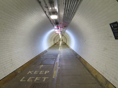
Stop 4: Woolwich Foot Tunnel

This tunnel opened in 1912 and was in part due to the efforts of East End politician, Will Crook who we heard about in E14. The surface building is now Grade II listed.
Inside there is a lift and a spiral staircase. The lift has been automated but still has the old wooden panels inside, even if it no longer has a lift attendant.

The number of people using the foot tunnel has declined particularly since the opening of the DLR service to Woolwich. It was eerily quiet when I was there.
Back on the surface, there is probably the most depressing bus terminal in London.
And just across the road is probably the most depressing riverside park in London. Clearly some money was spent on this once, as there are these various bits of industrial heritage artfully distributed.

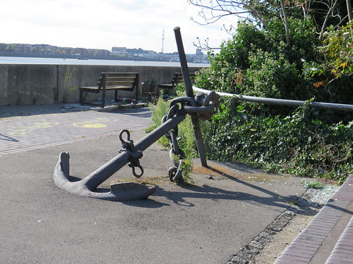
But the area is strewn with litter and in many places it is overgrown. Have the authorities forgotten that this exists? Maybe once the vacant land near here gets built on, someone will find the money to rehabilitate this riverside garden.
Continue along Pier Road and then turn up Henley Road walking away from the river. Turn left into Factory Road.
As we walk along Factory Road we see indications of some Crossrail works, which are where the old railway line to North Woolwich used to be. Here the line is on the surface and about to go into a tunnel under the Thames to get to Woolwich and Abbey Wood.


As we head down Factory Road, a strange sight looms up. It is a chinese style canopy.
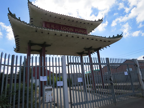
And it turns out to be announcing the entrance to a Chinese cash and carry supermarket. It looks like it is closed, though, judging by the signs.

There does seem to be quite a random selection of business down here. Just along a side road here there is a bus garage.

This is the home of Docklands Buses which is actually a subsidiary of Go-Ahead London.
Continue walking along Factory Road and you will see our next stop up ahead on the left.
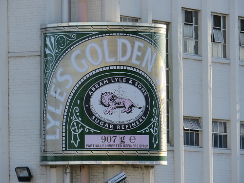
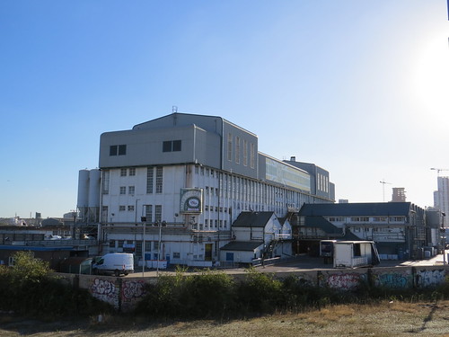
Stop 5: Tate & Lyle Silvertown refinery
This is the Thames Refinery operated by Tate and Lyle and one of the largest sugar refinery in the world and possibly the largest in the European Union.
It was opened by Henry Tate and Sons in the late 1870s. They manufactured sugar cubes here. Tate had not invented the sugar cube. In 1872, Henry Tate purchased the patent from a German called Eugen Langen and it made Tate’s fortune. That year he built a new refinery in Liverpool and later he opened a refinery here at Silvertown which remains in production.

Curiously there is a sign for Lyle’s Golden Syrup. It seems odd to find it here as we shall see.

Stop 6: site of Silvertown station
Just here we are walking along side the old railway line that went to North Woolwich which was closed in 2006. As we saw this section is being reused for the Abbey Wood branch of Crossrail. There is a little gap in the wall where you can peek through to see the work in progress.

Ahead you will see a footbridge on the right. If you go up onto that you can look at the line below. The tracks are laid but the overhead power lines have yet to go up.

Just about here was the site of Silvertown station – no sign of this survives today. And there will be no station here when Crossrail opens in a couple of years. However there is what is called passive provision for a station, so one may get built at some point in the future – presumably once more of the land round here gets redeveloped.
And looking the other way (to the west) the line curves off to the right and heads towards the Connaught Tunnel, which has been rebuilt for Crossrail.

You can also see a strange looking building to the left that looks like it might have escaped from Disneyland. That is our next stop which you reach by returning to Factory Road, turning right and carrying straight on.
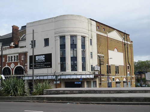
Stop 7: Brick Lane Music Hall
This was St Mark’s Church dedicated in 1862. It is in gothic revival style and was built to stand out amongst the docks and industry.
The church was declared redundant in 1974 and bought in 1979 by Newham Council, with the intention of turning it into a museum. A major fire in 1981 largely destroyed the roof, which was replaced between 1984 and 1989. Wikipedia says that “the building could have been destroyed by fire had it not been for the weight of pigeon-muck on the roof which fell and quickly extinguished the flames.”

On closer inspection this building is no longer a church but a venture called the Brick Lane Music Hall.
Their website claims it is “the only permanent home for music hall, we have a range of shows including traditional music hall bills as well as freshly devised production shows with more up to date and innovative material.”
As the name suggests it started life in Brick Lane – that was in 1992. It then moved to Shoreditch and ended up here in 2003/04. And what a good use for the building.
However it does feel quite out of the way for a place of entertainment. I am sure many people would not feel safe here at night, even today when the area is at last getting some new development.
Continue walking straight ahead. You will see the DLR viaduct coming in from your right. Past the roundabout the road continues as North Woolwich Road. Follow the DLR viaduct.
Our next stop is just to the left.
Stop 8: Thames Barrier Park
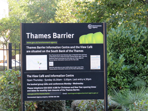
The Thames Barrier is a movable flood barrier which has been operational since 1984. Its aim is to protect London wast of here from being flooded by exceptionally high tides and storm surges moving up river from the North Sea. You first see the barrier in the distance along a road behind a gate..

But then you come to a park with great views of the Barrier. This park which dates from 1995 was apparently built on the site of a chemical factory and this land was highly polluted.
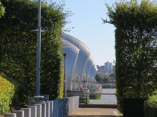

There is a visitors’ centre for the Barrier but it is on the other side of the River. but on this side there is a cafe and a rather lovely “Green Dock”

Now head away from the river towards the DLR viaduct and Pontoon Dock station.
Stop 9: Millennium Mills
Our next stop can be seen from the station. This is the imposing Millennium Mills.

Apparently this area was important for flour milling. This particular building is one of the few reminders. It dates from the mid 1930s and was built for Spillers. There have been many plans to redevelop or reuse this site since the docks were closed in 1981, but it does look like something is finally about to happen.
Now continue along North Woolwich Road past Pontoon Dock Station and turn left down Bradfield Road. Ahead of you on the left you will see a little park.
Stop 10: Lyle Park
In 1924, Sir Leonard Lyle, a grandson of Abram Lyle (the Lyle of Tate and Lyle), donated the land to the local council to be used as a park for the benefit of local residents.
As you approach the park, the first gate you come to may be locked but if you carry on to your right, there is another gate near the children’s play area and you can get in there.
It is worth a detour as there are a couple of interesting things to see.
As you walk in the park widens out and there is a single football pitch. Go to the right and in the far corner you will come across this little monument.

This is a First World War Memorial in the form of a water fountain.
And amazingly the tap actually works. When pushed it produces water!
Now walk the length of the football pitch and go up the steps. Ahead is another item of interest – a set of ornamental gates leading to nowhere.

The sign explains these gates stood at the entrance to the Harland and Woolf shipyard in Woolwich Manor Way – which confusingly is actually on the north side of the river in E16 and not in Woolwich.

Harland and Woolf is most famously associated with Belfast and their shipyard there was where the ill fated Titanic was built. I had not realised the company had a number of other locations, including here in North Woolwich.
You can walk over to the riverside here and see the odd mix of wharves and other industrial buildings with a sprinkling of new housing developments.


And there is a nice touch on one of the benches.
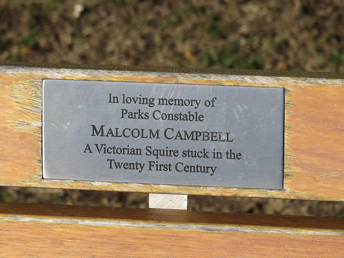
I guess a fairly recent addition, but frustratingly whoever sponsored the seat did not think to put a date or dates on the little plaque.
Now retrace your steps to the main road. Notice how this little park is hemmed in by industrial sites even today – in fact on the west side there is a construction waste processing plant which you can see in a couple of places looming over the boundary. You can also hear the noise of the operation with the odd boom shattering the otherwise tranquil park.

Stop 11: Tate & Lyle’s other works
Having left Lyle Park go back under the DLR and turn left. Follow the main road (with the DLR above your head) past the new housing developments going down to the river.

Ahead is West Silvertown DLR station and when you get to the station you can see on the other side of the viaduct the other Tate and Lyle factory here.
We are around a mile from the Thames Refinery and this is Plaistow Wharf. It is the home of Lyle’s Golden Syrup and was first opened by Abram Lyle in the 1880s. And it still makes Golden Syrup today.
In 1921 Lyle’s business merged with Tate, to become Tate & Lyle. In 2010 Tate & Lyle sold its sugar refining and golden syrup business to American Sugar Refining, although Tate and Lyle still exists as a business – it just does not refine sugar anymore.
What is so odd is that with all the closures and rationalisations that happen in business, the Tate and Lyle empire have kept the two factories here, even though they are so close together.
Lyle’s Golden Syrup tin bears a picture of a dead lion with a swarm of bees and the slogan “Out of the strong came forth sweetness”. This is a reference to a Old Testament Biblical story (Judges – Chapter 14) This has Samson travelling to the land of the Philistines in search of a wife. During the journey he killed a lion, and when he passed the same spot on his return he noticed that some bees had colonised in the carcass.
Samson later turned this into a riddle: “Out of the eater came forth meat and out of the strong came forth sweetness”. Abram Lyle was a religious man, and it has been suggested that the use of this quote refers either to the strength of the Lyle company or the tins in which golden syrup is sold. But no one actually knows for sure.
And according to Guinness World Records Lyle’s Golden Syrup is Britain’s oldest brand, its imagery being almost unchanged since 1885.
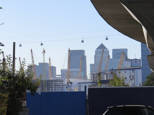
While we are here do look ahead from the station.

You get a great view of Canary Wharf and also the cable car.
We are now at the end of our E16 walk which has proved a walk of contrasts. A new world is slowing emerging from the industrial dereliction but it still has pockets of working industry which makes for an interesting mix. But there is more to see in E16 – we did not manage to get to Canning Town or London City Airport for example.
We are right by West Silvertown station here for onward travel.