SE27: Into the Wood

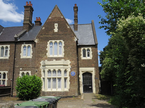
SE27 is West Norwood. This is another of those places I have been though but apart from once going to the cemetery, I do not think I have actually walked there.

The name Norwood comes from the “Great North Wood” – the hilly and wooded area to the north of Croydon. This area was originally known as “Lower Norwood”, to differentiate it from Upper Norwood, but as so often happened people did not like the implication of being in a place called “Lower”. The  station was renamed in the 1880s which changed the name of the whole locality.

We start our walk at West Norwood Post Office which is at 12 Knight’s Hill. Turn left out of the Post Office and immediately go down the side street, Nettlefold Place. Our first stop is almost straight ahead as the road bends to the left.

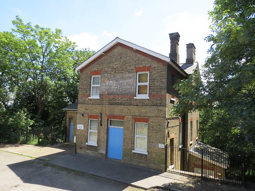
Stop 1: The Clockworks, Nettlefold Place

This industrial looking building is called The Clockworks.

IMG_4881

IMG_4882

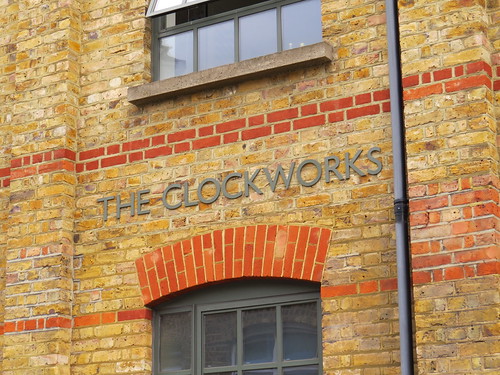
The Clockworks is a space that combines a museum, workshop, library and meeting space under one roof for people interested in the measurement and distribution of time using electric clocks. (Who knew that such a place existed!)

The Museum at The Clockworks houses a collection of electric clocks and related devices dating from the mid-nineteenth century to the 1970s. The collection is not restricted to timekeeping but also branches out into allied fields, such as early electricity metering and fire alarm telegraphy – both fields in which the early electric clock pioneers were also active. It is open by appointment.

More info about The Clockworks at: http://theclockworks.org/

Now retrace your steps to the main road and turn right. Our next stop is just past the Post Office on Knight’s Hill.

Stop 2: The old Library

This was the original library in West Norwood

IMG_4916

The West Norwood Free Public Library opened on 21 July 1888. It was commissioned by Sir Henry Tate on land donated by Frederick Nettlefold, who laid the foundation stone on 26 November 1887. The building was designed Sidney Smith, architect of Tate Britain and several other Lambeth libraries.

A new Library Building was opened nearby in April 1969 by Princess Margaret. Since then the ‘Old Library’ has been used by community groups and Lambeth’s youth service. However it is temporarily a library again as the 1960s building is currently being renovated as we shall shortly see.

Now head back down Knight’s Hill and keep going along the continuation which is Norwood Road. Our next stop is a little way along on the left.

Stop 3 Site of Regal Cinema, Number 322 Norwood Road,

IMG_4894

This is an unusual B & Q store being right on a main road. The site as you might have guessed was once home to a cinema. according to the wonderful Cinema Treasures site this was the location of the Regal Cinema. Built for A E Abrahams, it opened in January 1930. Acquired by the Hyams & Gale chain in April 1933, it was then taken over by Gaumont British Theatres in October 1935.

The Regal Cinema was closed by the Rank Organisation in February 1964. It then became a bingo club which lasted to 1978. The cinema building was demolished in November 1981.

Now keep going down Norwood Road until you get to Ullswater Road. On the right you will see an old Fire Station, which is now a children’s’ nursery.

IMG_4955

But look to the left of that and you will see an arched entrance way. That is what we have come to see.

Stop 4: The former Tram Depot

Today this archway leads to a self storage facility. I looked at this and thought it might have a story and indeed it does.

IMG_4958

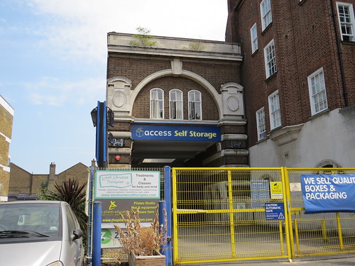
This was built as a tram depot in 1909 by the London County Council (LCC).

IMG_4957

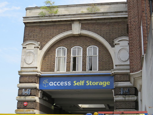
There is nothing to indicate this from the outside but with a bit a delving I found a picture of the tram depot in 1951

https://thetransportlibrary.co.uk/index.php?route=product/product&path=2&product_id=84181

Just think this was only a tram depot for just over 40 years. Since the last trams ran in the early 1950s, it has been something else for longer than it was a tram depot.

Now retrace your steps along Norwood Road.

As you go you may spot the odd LCC Tramways manhole cover in the pavement. LCC trams were unusual in that they had their power supply in a conduit between the rails rather than from the more usual overhead wire. And so the electrical system for the trams was buried in the street with these access points..

IMG_4963

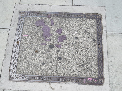
These survive even though the trams have long since disappeared..

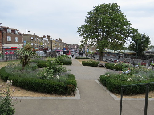
At the end of Norwood Road, the street forks and in between sits St Luke’s Church. But before we get to that, turn left into West Norwood Cemetery.

Stop 5: West Norwood Cemetery

IMG_4892

West Norwood Cemetery – or The South Metropolitan Cemetery as it was first known – was one of the first large commercial, inter-denominational cemeteries in London, opening in 1837. The old city churchyards were getting over crowded and were polluting the areas around them, so new burial grounds were sought in what was then countryside. West Norwood Cemetery is one of the so-called magnificent seven Victorian cemeteries.

IMG_4965

It was designed by Sir William Tite (1798 – 1873), who was perhaps more famous for his railway stations. He planned the Episcopal (Anglican) and Dissenters’ (nonconformist) Chapels, both including catacombs beneath, which together could accommodate some 3,500 coffins. Provision was made not only for privately purchased family graves and vaults, but also for paupers’ burials in common graves.

He also designed the grand arch at the main entrance. The shield over the centre of the arch is that of the diocese of Canterbury.

Soon the South Metropolitan became the most fashionable cemetery in south London, known as the ‘Millionaires’ Cemetery’ from the quality of its mausoleums and other elaborate monuments. Not all the original buildings have survived.

Unlike some of the other magnificent seven cemeteries, this one was taken over by the local council, Lambeth who compulsorily purchased it in 1965.

More about the history can be found here:

https://www.fownc.org/

There are a lot of well known people buried here.To help find your way found here is a map:

https://www.google.co.uk/search?q=west+norwood+cemetery+plan&tbm=isch&tbo=u&source=univ&sa=X&ved=2ahUKEwjBqKjQhcrcAhXDDMAKHQq8C3kQ7Al6BAgKEA0&biw=1920&bih=898#imgrc=qobqFC1aeYsVQM:

This shows how the cemetery is divided into squares each with a number and you can just about work out where a grave is if you have that square reference.

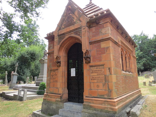
I tracked down three. First was the Tate family mausoleum dating from the 1890s. If you follow the road to the crematorium and go past it, the Tate vault is just a little further as the road turns.

This is Plot 19897 in Square 38.

IMG_4967

IMG_4968

More info at https://www.findagrave.com/memorial/13832960/henry-tate

Then if you look ahead and slightly to the left you will see a path going off. This is Doulton Path.

IMG_4977

And not surprisingly this is where the Doulton family mausoleum is to be found.

This is Plot 22589 in Square 36

IMG_4975

IMG_4973

IMG_4976

More info at: https://www.findagrave.com/memorial/15606517/henry-doulton

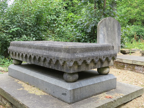
There are a lot of well known people buried here including, cookery writer, Mrs Beeton (Plot 8348, Square 64); Paul Julius Reuter (Plot 28319, Square 23); architect William Burges (Plot 4478, Square 34); and builder Thomas Cubitt (Plot 649, Square 48). I did not get to find these however one I did find was that of Sir Horace Jones (Plot 12335, Square 89). This is along a small walkway called Ship Path which runs parallel to the main road to the Crematorium.

IMG_4980

Who was he, I hear you say. Well Sir Horace Jones (1819 – 1887) was particularly noted for his work as Architect and Surveyor to the City of London from 1864 until his death.

He designed and built some of London’s most famous markets – Smithfield, Billingsgate and Leadenhall. He also designed the memorial at Temple Bar at the boundary between the Cities of London and Westminster. But his most recognised work was Tower Bridge, which was completed posthumously.

IMG_4978

Now retrace your steps out of the cemetery.

As you head towards the lodge by the main gates have a look out for this grave on the left hand side. This is the grave of Sir Hiram Maxim – Plot 34481 in Square 124.

IMG_4907

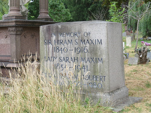
Maxim is not a famous name, but he is known for creating the first portable, self powered, fully automatic machine gun. As such, it is credited for changing army tactics in the early 20th Century.

https://www.findagrave.com/memorial/16417890/hiram-stevens-maxim

He lived locally in Norwood Road towards Tulse Hill and developed his machine gun in the garden of his house, much to his neighbours annoyance. The house has been demolished and I have been unable to establish just where it might have been. Hence I did not include it when we were in Norwood Road.

At the gates, turn left. Our next stop is straight ahead.

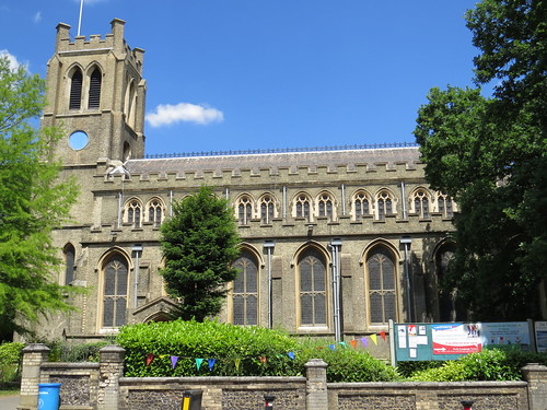
Stop 6: St Luke’s Church

This is a wonderful set piece and apart from the cemetery, really the rest of West Norwood does not live up to this vista.

IMG_4887

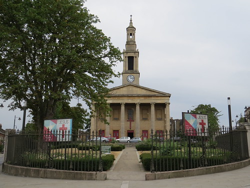
St Luke’s Church was designed by Francis Octavius Bedford in 1822, as a result of the Church Building Act of 1818, which had been passed in response to the end of the Napoleonic wars and the growing urban population. It is known as a “Waterloo church” or a “Commissioners’ church” because it received a grant from the Church Building Commission towards the cost of its construction.

Unusually it is oriented north-south instead of east-west. This is due to a stipulation in the original planning permission that no building in what was then called Lower Norwood should be built within 100 feet of an existing building without the permission of the owner of the other building. An objection from the owner of the Horn’s Tavern meant St Luke’s had to be built in a north-south orientation to avoid falling within 100 feet of the tavern. But that did mean it could be sited it what turned out to be a rather pleasing way.

Inside the church was originally ordered by the main altar on the long east wall but this was changed in the 1870s. and was reordered again in 1972 according to architectural guru, Pevsner.

If you look back from the church you can see the triangular garden which has been created

IMG_4913

There is a small plaque which notes this was rededicated in 2009 and commemorates the residents of West Norwood who lost their lives, or who served at home or abroad during the Second World War.

IMG_4912

Our next stop is just to the right of the garden as you look down the garden from the main front of the church.

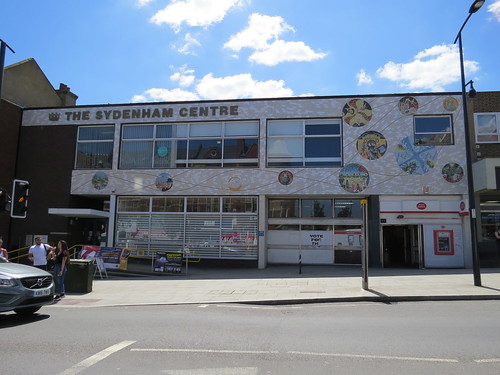
Stop 7: former Nettlefold Hall and Library

This is where the library moved in 1969.

IMG_4953

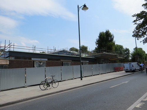
Pevsner calls it “dignified yet inviting”. Although you cannot see it from the road there is a hall behind the library building.

Today the  site is undergoing a transformation. The Nettlefold and West Norwood Library Redevelopment is an ambitious proposal to provide a town centre library, together with a cinema and café. Lambeth Council has partnered with Picturehouse Cinemas to do this. It seems that this was supposed to have been completed last year but it is clearly running late.

Nice to see the building being revitalised like this, but with a new cinema coming up the road in Crystal Palace and a Picturehouse opened in 2015 in East Dulwich, you have to wonder whether there will be enough business for all these new screens.

Now head along the road to the left of the church. Our next stop is just on the right.

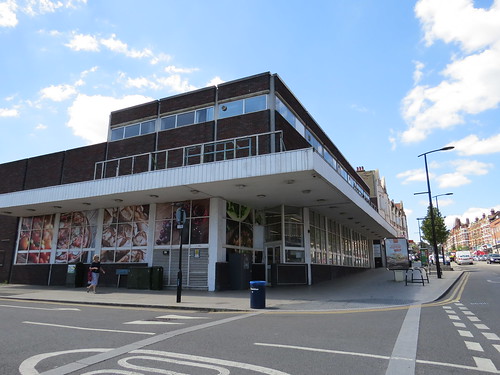
Stop 8: South London Theatre

This building was the original fire station dating from 1881. But it had a short life as a fire station because it was built for horse-drawn fire engines and when motorised appliances were introduced they too big for the doors. It was too difficult and/or expensive to alter this building, so a new one was built in Norwood Road – that is the one we saw next to the old tram depot. That in turn has been replaced with something larger and more modern, which is just up Knight’s Hill.

IMG_4949

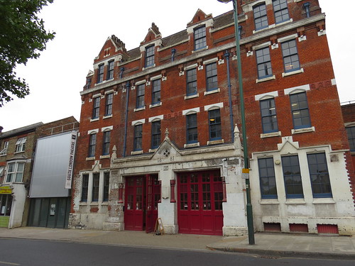
After the fire station moved this building was used by the local church as its hall. Then in 1967, it was converted into a theatre space designed by Brutalist architect Owen Luder – we saw his work in SE6 as he was responsible for the Catford Shopping Centre.

It is a non professional theatre which aims to produce at least 15 shows a year. The building has just undergone a major restoration and awaits its formal reopening, I understand.

More about the South London Theatre at: http://www.southlondontheatre.co.uk/who-we-are/

Now continue along this road which is Norwood High Street and take the next right.

Ahead on the left is the side entrance to our next stop. The main entrance is up the road and around the corner in Knight’s Hill.

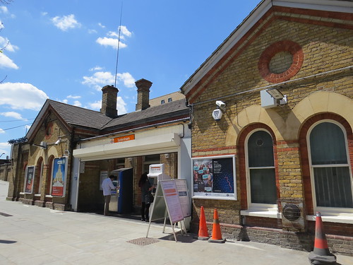
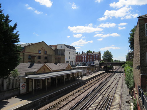
Stop 9: West Norwood station

This is a somewhat uninspiring station.

IMG_4878

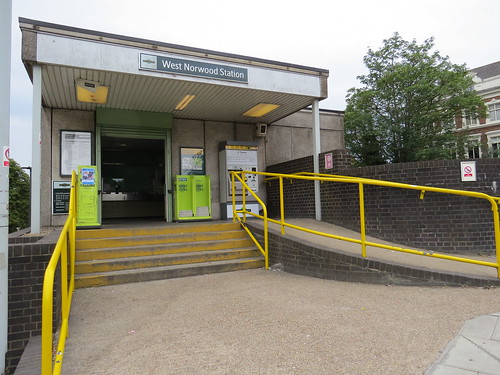
Go through the overgrown portacabin of a ticket office and you go onto an open bridge with the almost bare platforms below.

IMG_4876

IMG_4873

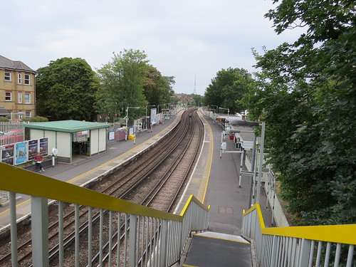
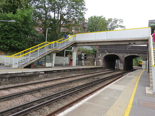
The station was originally opened in December 1856, as part of the West End of London and Crystal Palace Railway which linked into existing lines at Crystal Palace and Balham.

At first it was called Lower Norwood but it was renamed on 1 January 1886. As the area became developed the new residents disliked the connotation of “Lower” and so as explained above the station got renamed “West Norwood” which led to the whole area changing its name..

The line from Victoria to Crystal Palace was electrified in 1911 by the London Brighton and South Coast Railway using an AC overhead wire system. But with the creation of the Southern Railway in 1923, they inherited two different electrification systems and opted to standardise on a third rail DC system used by the London and South Western Railway. The line here was converted to this in March 1929.

The original station buildings were demolished in 1969, and replaced with these rather awful prefabricated buildings.

Now if you are at the main ticket office (or what passes for one) turn left and continue up Knight’s Hill. Our next stop is soon on the right.

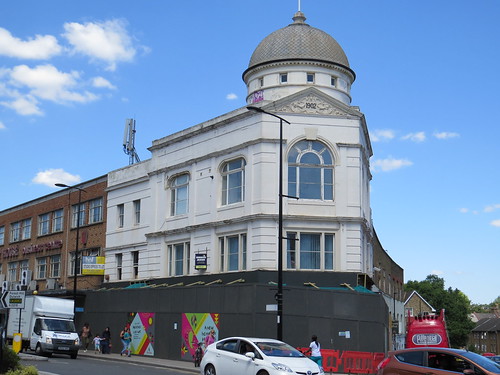
Stop 10: Number 76 Knight’s Hill (former Royal Cinema)

IMG_4924

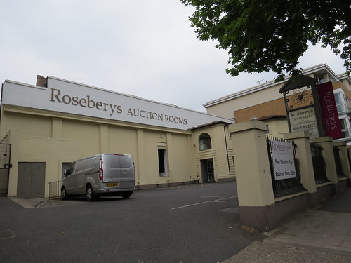
Just here is an unusual kind of place – an auction room. Not what you expect to find in deepest south east London. But in fact this building started off life as a cinema, according to Cinema Treasures. First called The West Norwood Picture Palace it was opened prior to 1929. Then it was renamed Cosy Cinema in 1933 and the Royal Cinema in 1937.

The Royal Cinema was closed in 1955. The auditorium survived but the front section was demolished and replaced by a garage forecourt, which explains today’s odd layout. Since around 2000, Rosebery’s Auction Rooms operate from the former auditorium.

Now continue along Knight’s Hill and soon on the left you will see our next stop.

Stop 11: Norwood Bus Garage

Although it does not look like it, there has been a bus garage here since 1909 when the London General Omnibus Company first opened one here. This makes it one of the oldest motor bus garage sites.

IMG_4925

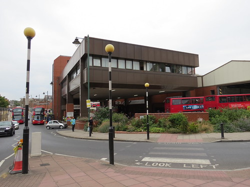
The building was however rebuilt entirely in the early 1980s and looks like one of those bus stations you get in provincial English towns. Not really much more to say about it.

IMG_4928

Now on the Knights Hill side of the bus garage, there is a patch of rough garden, which is our next stop.

Stop 12: Norwood Bzz Garage

This is a community run garden created to attract bees – The Norwood Bzz Garage. There is an interesting analogy. The bus garage is as busy as a bee hive, and the buses coming home at dusk are just like bees and a bee hive at the end of the day.

IMG_4930

http://www.thisislocallondon.co.uk/youngreporter/16192546.Bees_Found_In_West_Norwood_Bzz_Garage/

Above the garden is a banner with a poem by Carol Ann Duffy called “A Rare Bee”

IMG_4932

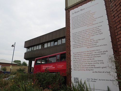
This is more significant than it first appears. The banner has been coated with a new product branded PURETi, which is a harmless substrate made of Titanium Nitrate. This substrate uses light to activate the agent which then transforms NOx (Nitrogen Oxides) into harmless by-products (Water and Carbon Dioxide) and mineral nitrates (Calcium Nitrate) which is in effect fertiliser. Rain runs down the banner and falls on the Bzz Garage garden below taking the Calcium Nitrate with it.

We are now at the end of our SE27 walk. I knew that the cemetery would be rewarding but it was nice to find some other interesting features like a “Waterloo” church, the old and new libraries, an old tram depot and a newish bus garage plus a theatre in a very old Fire Station. Shame I did not mange to find any blue plaques!

There are various buses here for onward travel or else just return down Knight’s Hill to West Norwood station.

SE26: Taking the waters (in Sydenham?)

SE26 is Sydenham. A bit of a sprawling place and another one of those districts which is quite hard to place on a map. We start at the Post Office, 44 Sydenham Road and which is in fact our first stop.

Stop 1: Sydenham Centre

I think the Post Office once took up the whole of this building but now it is in just a part and the rest seems to be called “The Sydenham Centre”

IMG_4624

According to Lewwisham Council’s website:

“The Sydenham Centre is a vibrant community space that holds a mix of local organisations, events, activities and services for local and vulnerable people.

The Centre’s main focus is around arts, dance, physical movement and wellbeing activities.

The Sydenham Centre provides the following:

  • day activities for people with learning disabilities
  • micro-brewery which provides training and employment opportunities for people with learning disabilities
  • hireable activity space.”

One interesting feature is the mosaic on the exterior which celebrates all things Sydenham, from Camille Pissarro and Ernest Shackleton to bomb damage.

IMG_4623

There are some 11 roundels in total and at the left there is a key to the various elements of the mosaic.

IMG_4629

This indicates the artist is Oliver Budd of Budd Mosaics

The company was established by mosaic artist Kenneth Budd in 1951 and more than 60 years later second-generation mosaic artist Oliver Budd designs and creates custom-made mosaics for home and abroad.

Here is a link to their website: http://www.buddmosaics.co.uk/index.html

Now interestingly according to the wonderful Cinema Treasures site, this was the site of a cinema which opened in October 1910 as The Queen’s Hall Electric Theatre. It was taken over by the Army Service Corp. in the spring of 1917, during the First World War, and it was closed. It didn’t reopen until August 1919. In late 1936, alterations were carried out and it was reopened in January 1937 as the Classic Cinema.

It was renamed Naborhood Cinema in May 1939 (what a great name!). It received some slight bomb damage in 1943, and was closed. It never reopened and was demolished in August/September 1953. And as we have seen Sydenham Post Office was built on the site and now having been downsized, the building is largely a community facility.

Now go as if you were turning right out of the Post Office and head down Sydenham Road until you reach Girton Road. Our next stop is at the dead supermarket at the corner.

Stop 2: site of another cinema, 72-78 Sydenham Road

IMG_4632

According to Cinema Treasures, this too was the site of a cinema. Opened in August 1931, as the State Cinema, it was built for and designed by A.C. Matthews. It was opened on 1st August 1931. He was also responsible for the couple of cinemas we saw in SE19.

It was taken over by Excelsior Super Cinemas in October 1933 and then in March 1949, they were taken over by the Granada chain. It was renamed Granada in October 1949.

The Granada was not split up nor turned over to bingo and carried on as a single cinema until it closed in April 1971. It was demolished later that year. A Safeway Supermarket was built on the site. This later became Somerfield and finally a Co-operative Food store. Today it is closed.

Now head back along Sydenham Road and a little past the Post Office you will see a railway bridge. Turn right just before that for our next stop.

Stop 3: Sydenham station

This is another of the stations built by the London and Croydon Railway which took over much of the alignment of the Croydon Canal  The first station here opened in 1839 and was located to the south of the railway bridge.

With the construction of the branch to Crystal Palace in the early 1850s, the country bound platform  was resited to its current position, north of the railway bridge. The London bound platform remained with a station building on Sydenham Road by the bridge. This meant the station had an unusual staggered platform arrangement.

Today the station building on the bridge has long gone and the main station building is down the side street on the right. This is just before the bridge on the country bound side of the tracks. It presumably dates from the 1850s when the line was rebuilt.

IMG_4620

IMG_4618

Today if you go onto the station you will see the platforms are staggered but not in the way they used to be.

IMG_4613

IMG_4610

The reason the London bound platform looks a bit spartan is that it is relatively new.

IMG_4607

The northbound platform only dates from 1982 when British Rail decided to construct a replacement platform 90 meters north, parallel to Peak Hill Gardens. This was because the retaining wall at the original location was beginning to collapse.

Now go back to the main road and turn right. you will see a roundabout ahead of you. And to the right you will see a distinctive building with a dome. This is known locally as Cobb’s Corner and is our next stop.

Stop 4: Cobb’s Corner

IMG_4636

IMG_4634

This used to be Cobb’s Deparment Store. The store was started by Walter Cobb as a small draper’s shop in 1860. It gradually grew until it became a fully fledged Department Store building. This corner became the main entrance in 1902. The shop was very badly damaged by bombing in October 1940 and although it was rebuilt the store gradually declined.

Cobb’s continued to trade until 1981 which is kind of surprising as Sydenham never developed in to a major shopping centre.

There is an excellent piece in Cobb’s on the Sydenham and Forest Hill Local History site.

http://sydenhamforesthillhistory.blogspot.com/2009/01/cobbs-department-store-sydenham.html

Now return to the roundabout and go down the main road on the left. This is Westwood Hill. Our next stop is soon on the right hand side.

Stop 5: St Bartholomew’s Church

IMG_4645

According to architectural guru, Pevsner, this church dates from 1827 – 1832 and is of stock brick. Pevsner does not rave about this church, but nor is there any withering comment.

In the church grounds, near the entrance to the church, is the grave of 10 men who died during the rebuilding of the Crystal Palace in Sydenham in 1853 when the scaffolding they were on collapsed.

But I guess its main claim to fame is that the church features in the 1871 painting by Camille Pissaro called “The Avenue, Sydenham”. This painting is owned by the National Gallery and is one of a number Pissaro painted around here when he was staying locally in what today we call SE19.

Our next stop is almost immediately next door on the right.

Stop 5: Number 12 Westwood Hill

IMG_4647

You will see there is a blue plaque. This denotes the fact that antarctic explorer, Sir Ernest Shackleton lived here.

IMG_4648

Sir Ernest Shackleton (1874 – 1922) was a polar explorer who was involved in three British expeditions to the Antarctic. He was born in County Kildare, Ireland and his  father, a newly qualified doctor, moved the family here to Sydenham when Ernest was ten.

Ernest Shackleton has an extensive Wikipedia entry – https://en.wikipedia.org/wiki/Ernest_Shackleton

According to this, his first experience of the polar regions was as third officer on Captain Robert Falcon Scott’s Discovery Expedition 1901–1904, from which he was sent home early on health grounds.

During the second expedition 1907–1909 he and three companions established a new record of getting the farthest south – to the latitude 88°S, around 100 miles from the South Pole. This was regarded as the largest advance to the pole in exploration history. Also, members of his team climbed Mount Erebus, the most active Antarctic volcano. For these achievements, Shackleton was knighted.

After the race to the South Pole ended in December 1911 with Roald Amundsen’s conquest, Shackleton turned his attention to the crossing of Antarctica from sea to sea, via the pole. To this end he made preparations for what became the Imperial Trans-Antarctic Expedition, 1914–17. Disaster struck this expedition when its ship, Endurance, became trapped in pack ice and was slowly crushed before the shore parties could be landed. The crew escaped by camping on the sea ice until it disintegrated, then by launching the lifeboats to reach Elephant Island and ultimately the inhabited island of South Georgia, a stormy ocean voyage of 720 nautical miles and Shackleton’s most famous exploit.

In 1921, he returned to the Antarctic with the Shackleton–Rowett Expedition, but died of a heart attack while his ship was moored in South Georgia. At his wife’s request he was buried there.

Our next stop is right next door and also has a blue plaque.

Stop 6: Number 14 Westwood Hill

IMG_4653

This blue plaque is for Sir George Grove, who could not have been more different from Shackleton.

IMG_4652

Sir George Grove (1820 – 1900) was an English writer on music, best known as the founding editor of Grove’s Dictionary of Music and Musicians.

Grove was trained as a civil engineer, but his love of music drew him into musical administration. When responsible for the regular orchestral concerts at the Crystal Palace, he wrote a series of programme notes from which eventually grew his musical dictionary.

He edited the “Dictionary of Music and Musicians” which was first published in four volumes (1879, 1880, 1883, 1889).

The second edition, in five volumes, was edited by Fuller Maitland and published from 1904 to 1910, this time as Grove’s Dictionary of Music and Musicians. It has gone through several editions since. The latest print version runs to 29 volumes. In recent years it has been made available as an electronic resource called Grove Music Online.

Grove was also involved in the creation of the Royal College of Music in 1882 and was its first Director.

He died here aged 79 on 28 May 1900, in the house in which he had lived for nearly 40 years.

Now continue along Westwood Hill and take the first turning on the right – Jews Walk. Our next stop is a little way down on the right hand side.

Stop 7: Number 7 Jew’s Walk

Number 7 is nestled in a garden surrounded by trees and scrubs.

IMG_4654

But you can just make out a blue plaque. This notes that socialist campaigner Eleanor Marx lived and died here.

IMG_4656

She was the youngest daughter of Karl Marx. She was a socialist activist who sometimes worked as a literary translator.

There is a fascinating post here from the Sydenham and Forest Hill Local History site

http://sydenhamforesthillhistory.blogspot.com/search/label/Jews%20Walk

It is by no means clear why she chose to live here but this piece does suggest that she was attracted by the name of the street given her Jewish heritage.

The piece also tells the sad tale of her suicide. In March 1898, after discovering that Edward Aveling, her partner and a prominent British Marxist, had secretly married a young actress in June of the previous year, she committed suicide by poison. She was 43. The piece mentions that Dr Henry Shackleton, father of Edward, was called when she was found dying.

Now go down the side road almost opposite – Longton Grove. When this bends to the left take the turning on the right – Longton Avenue. Soon ahead of you on the right you will see an entrance to a park. Go in there as it is our next stop.

Stop 8: Sydenham Wells Park

IMG_4658

The name of this park is a bit of a giveaway, because this was once the location of a spa.

IMG_4663

Keep walking though until you get to the formal garden bit.

IMG_4666

Just beyond here is a stone with a water drain underneath. I guess this maybe something to do with one of the natural springs – or at least a reminder of what used to be here.

IMG_4676

According to London Gardens Online:

“Sydenham Wells Park is near the former site of mineral springs that were discovered in the C17th, becoming a popular spa whose numerous visitors included King George III. The spa’s success led to the building of larger houses, and wealthy people began to settle in the area. The opening of Crystal Park encouraged further influx. Sydenham Wells Park opened as a public park in 1901 following a campaign to save the land from being built over by housing development.”

More info at:

http://www.londongardensonline.org.uk/gardens-online-record.php?ID=LEW052

Now head through the park and out the other side. You will either come out to Longton Avenue (in which case turn right) or Wells Park Road (in which case turn left). Go along Wells Park Road away from the park and soon on the left you will see a home set back off the road at a slightly lower level. This is our next stop.

Stop 9: Site of Upper Sydenham station

IMG_4681

This house is pretty much all that is left of Upper Sydenham station which was on the line which went to Crystal Palace High Level.

The station was opened by the London, Chatham and Dover Railway in August 1884. It was temporarily closed as an economy measure in both World Wars (January 1917 – March 1919 and May 1944 – March 1946).

Although the line was electrified in 1925, it was never a major route and lost much of its traffic after Crystal Palace burnt down in 1936. The line was permanently closed in September 1954

The station building sits atop a tunnel and the platforms were quite a long way down. There is little to see now but you can go down to the tunnel mouth if you follow the signed path.

IMG_4684

And then take a left into the woods

IMG_4686

If you look carefully you will see the mouth of the tunnel, though it is blocked off now.

IMG_4689

If you want to see what this station looked like before nature took over go to the fantastic Disused Station site:

http://www.disused-stations.org.uk/u/upper_sydenham/

This has lots of pictures of the station with its full complement of buildings and also just as a couple of forlorn platforms.

Now return to Wells Park Road and turn left. Continue to the end and at the main road you will see another road almost opposite with a pub at the corner. This is Crescent Wood Road, where we have our final two stops.

First up ahead on the left just after the green pathway is number 3.

Stop 10: Number 3, Crescent Wood Road

IMG_4701

If you look carefully at the right hand end of the main house is a blue plaque. This notes that television pioneer John Logie Baird (1888 – 1946) lived here

IMG_4699

He was a Scottish engineer and innovator. He was one of the inventors of the mechanical television, demonstrating the first working television system in 1926 and the world’s first colour transmission in July 1928, Whilst he was a great pioneer, it should be said the actual system he developed was a bit cumbersome and others would develop more workable solutions..

Fascinating fact: The demonstration of colour television in 1928 featured a young girl wearing different coloured hats. That girl was Noele Gordon who went on to become a TV presenter and actress, most famous for her leading role in the soap opera Crossroads.

Logie Baird had a  transmitter and TV studios at Crystal Palace but they were lost when the Palace was ravished by fire in 1936. I have not been able to confirm it but I guess he was living here because of his facility at Crystal Palace which is after all just up the road.

Our next stop is just across the street.

Stop 11: Six Pillars

Here we have a very striking modernist building called Six Pillars, because – guess what – it has six pillars at the front.

IMG_4704

This is clearly rather special.

IMG_4706

According to a February 2007 article in the Daily Telegraph https://www.telegraph.co.uk/finance/property/3356594/South-Londons-own-white-house.html

“Six Pillars was designed by Tecton, a London-based architectural practice led by the Russian émigré and master of the modern movement, Berthold Lubetkin. His best-known London works are the Penguin House at London Zoo and his apartment blocks, Highpoint, in Highgate, North London.”

“The main façade of the house, which faces the street, is a rectangle of concrete floating on six jaunty … pillars – whence the name – reached by a horseshoe-shaped drive. Outside it looks enormous. Internally, it spans 3,000 square feet, but [it has been likened] it to the Tardis in reverse. “It seems huge from the outside, but once you’re in, it’s not that big.””

“The four-bedroom house was built in 1934 as the residence of Jack Leakey, a former headmaster of nearby Dulwich College, and his wife. It is said that the pair’s ‘unconventional marriage’ may have influenced its unusual upstairs layout. Enter the double-volume entrance hall with its large window made up of small panes of glass, typical of the period, and a swooping curved concrete staircase leads to a choice of two separate wings, which were once ‘his and her’ bedroom suites.”

IMG_4703

So that brings us to the end of our SE26 walk. I had not expected to find quite so much of interest, certainly not to find myself at such an iconic house, or find four “proper” blue plaques.

We are quite a way from where we started. you can return to the main road and catch a bus (Number 202) back to Sydenham. Or else you can follow a green passage that will take you done the hill to Sydenham Hill station which is served by local trains running between London Victoria and Bromley/Orpington. There are usually four trains and hour plus some extras in the peaks.