When you look for property in SW19 you will see places advertised as being in Wimbledon Village, Wimbledon Park, Wimbledon, Merton Park and Merton Abbey. But sometimes you will find it just says plain old SW19. This generally turns out to be Colliers Wood, the bit of SW19 that dares not speak its name. I am sure that the folks who live on the hill (ie Wimbledon Village) probably do not even realise their postcode extends to Colliers Wood!
SW19 is huge and I cannot possibly cover it all. So I have decided not to do my SW19 walk in Wimbledon which most people associate with SW19 but I am going to start it right here in Colliers Wood.
We start at the Post Office in Christchurch Road just a couple of doors left out of Colliers Wood Tube Station. Come out of the Post Office and ahead you will see our first stop.
Stop 1: Former Brown and Root Tower
At 17 stories, this is the tallest building in the Borough of Merton and it has the distinction of having been voted the ugliest building in London in a 2006 BBC poll and one of the 12 ugliest in the UK in a 2005 Channel 4 poll for its programme Demolition.
Unaccountably it seems to have dropped off of the lists of ugliest buildings in more recent polls, but then I guess there is a lot of competition.
This tower was first known as the “Lyon Tower” as it was originally the headquarters of property company Ronald Lyon Holdings. But for most of its life it was known as the “Brown and Root” Tower because of the american construction company that occupied it.
It has been empty for years. Planning permission to develop the site was first granted in 2003 but not much has been done except to demolish the old car park structure at the back. Maybe 2014 will see something actually happen to the building and this eyesore will become something useful like a block of flats.
Just as a by the by: we are here at the end/beginning of one of the Mayor’s Super Cycle Highways. This was the first one to be finished – the CS7 which runs between Colliers Wood and the City. Note the map shows the route as almost a straight line. This is no accident because the main road here (A24) broadly follows the old Roman Road to Chichester. Interestingly just south of Colliers Wood the modern road veers off this straight alignment. The roman road would have had to cross the valley of the river Wandle here at an angle and maybe it was more practical to take a diversion to avoid the boggy areas around the river. But if you draw a straight line from here southwestward it goes though Merton Abbey Mills and Morden Hall Park and then south of Morden the modern road aligns with the roman one once again.
Now cross the main road and a little way along on the right you will see a park. Go in the gate.
Stop 2: Wandle Park
Wandle Park is owned by the National Trust but managed (after a fashion) by Merton Council. It is not what you would call a very pretty park, but it has some interesting history.
Almost immediately inside the gate is the first of two fountains – now both sadly out of use.
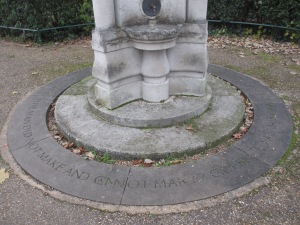
This stone drinking fountain was erected as a memorial to a man called John Feeney in 1907.
And there is a verse which runs as follows:
“Calm soul of all things! Make it mine
To feel, amid the city’s jar,
That there abides a peace of thine,
Man did not make, and cannot mar”
This feels almost biblical but actually it is by Victorian poet Matthew Arnold and is the penultimate verse of his poem “Lines written in Kensington Gardens” dating from 1852. Not such a calm position here today – being right by the entrance with the incessant traffic close by.
Now follow the path round and turn left over the bridge. Eventually you will come to a second fountain. This was erected through private subscription in memory of Henry Pollard Ashby ad his son in law Robert Bloomfield Fenwick (1835-1897), who had lived at Wandlebank House from 1867 to 1895.
Walking on from here you will see another bridge. This one is over the River Wandle. But before you do look ahead at the modern block of flats, this was the location of the Wandlebank House.
According to the Merton Council website, Wandlebank House was built in 1791 by James Perry and owned by him until his death in 1821. The house was demolished in 1962. Perry owned the corn mill next door (which we shall see shortly) and he was editor of the ‘Morning Chronicle’ newspaper. Perry was also associated with the construction of the Surrey Iron Railway which followed the Wandle valley and so would have run somewhere nearby, not that there is anything to see of that here now.
Go to the bridge.
Stop 3: Connolly’s Mill
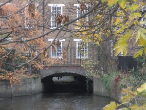
Pause a while on this bridge and have a look down stream. You will see a three storey building literally over the river. This is Connolly’s Mill.
This is a large former water mill building, dating from around 1805, and designed by the engineer John Rennie. This was the mill owned by James Perry, and according to the plaque is on or close to a site which has been used for milling for at least 750 years.The building was converted into flats in 1994. (By the way this plaque is actually on the left hand side of building as you approach it from the bridge you are just crossing).
Go over the bridge turn left and go down the street running by the river – imaginatively named “Wandle Bank”. At the end of Wandle Bank, turn right into Merton High Street and cross the road.
Stop 4: Merton Bus Garage
Just here is a big bus garage. It is only has a small facade to the street but it goes back a long way and can house well over 100 buses.
The garage was opened by the London General Omnibus Company in November 1913. And recently they had an open day to celebrate its centenary. It is rather fitting that this garage is now operated by the modern day London General bus company and the building next door (a former pub) is London General’s head office.
Useless fact: the code for Merton Garage is AL – see the SW15 walk for an explanation of these codes.
Opposite the bus garage, the river Wandle runs parallel to the street and on the other side of the river is a huge shop (now a combined Sainsbury’s and Marks and Spencer, but originally it was Sainsbury’s Savacenta).
Cross the bridge to the shop and go straight ahead, either through the ground floor area of the building or else skirting round it. You want to get to the other side of the car park almost directly opposite where you started.
Stop 5: The site of Merton Priory
You will see ahead of you a subway with a sign saying “Footpath to Merton Abbey Mills”.
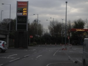
Stop a while here because just here at this edge of the car park and down towards the petrol station was the location of a medieval priory church.
Now this area is today called Merton Abbey but there never was an abbey here. Actually the monastic establishment here was called Merton Priory – a Priory is lower in the pecking order than an Abbey.
Merton Priory was established in the 12th century and has several claims to fame. Thomas Becket was educated here as was Walter de Merton, who went on to found Merton College, Oxford. It was the place where in the 1230s the first comprehensive statute since the Magna Carta was agreed. This was the Statute of Merton which allowed amongst other matters Lords of the Manor to enclose common land provided that sufficient pasture remained for their tenants. As this was the first recorded statute of the first recorded parliament, it can be viewed as the starting point for parliamentary democracy.
But with the dissolution of the monasteries in the 1530s, the buildings were largely demolished. Much of the stone was taken down the road to build Henry VIII’s Nonsuch Palace, which itself was later demolished.
There is a fascinating website with more info: http://www.mertonpriory.org/
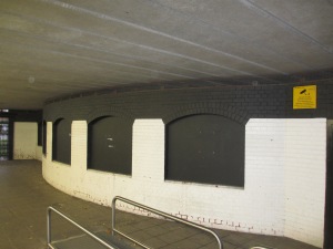
There is precious little left of Merton Priory today. We will see a gateway at the end of our walk and there is a bit of wall which we shall see shortly. But the most significant remains are actually below the road by the Sainsbury’s/M & S building. What is left of the Chapter House was preserved below the road built in the late 1980s (and fancifully called Merantun Way).
You cannot actually see the remains except on special open days because they are behind some sad boarded up windows. However it looks like some money has been found to sort this out at some point.
The plan is to create a new glass wall on the south side (other side from Supermarket) just by that pylon you can see in the picture above.
Now go under the subway under Merantun Way and across the car park taking a right on the service road. Ahead is our next stop.
Stop 6: Merton Abbey Mills
At Merton Abbey Mills, there is a reminder of the Wandle’s industrial heritage.
The Wandle powered a number of mills and so all sorts of industry sprung up along the banks. Here at Merton Abbey, a calico manufactory was established in 1724 and a second one in 1752. They not only bleached the cloth but also dyed it here.
William Morris, at the forefront of the Arts and Crafts Movement, relocated his dye works to Merton Abbey Mills in 1881 after determining that the water of the Wandle was suitable for dyeing. The complex, on 7 acres included several buildings and a dye works, and the various buildings were soon adapted for stained-glass, textile printing, and fabric and carpet weaving. The Morris works closed in 1940.
Another business associated with this location was Littler and Company. In 1875 Littler’s started to print goods for Liberty. The hand block printed quality that Littler used became synonymous with Liberty. Liberty’s purchased the Merton print works in 1904, ceasing production in 1972.
Today Merton Abbey Mills is a crafts market with food stalls, mainly operating at the weekend.
A number of buildings from the Morris period, and even earlier, survive, and there are displays on the history of the site. There is even one building surviving from the mid 18th century.
This is the Colourhouse built around 1740 or 1750 and today used as a children’s theatre.
And there is a working waterwheel dating from 1860. This is unusual in having seven spokes and is said to have been the inspiration for the Merton Council logo, which is a waterwheel.
The building now houses a pottery which uses the waterwheel.
This is a lovely enclave and could have been so much nicer. But the modern development around it sadly detracts from the atmosphere – especially the american style drive-through KFC and Pizza Hut buildings.
Cross the river by the water wheel building and then turn right, go over the main road at the crossing and pass through the archway.
This little arch is a reconstruction of an old archway but apparently some of the walls either side are the old wall of the priory.
Walk along the road ahead (this is Station Road, although the station has long since disappeared) and at the end turn right into Abbey Road. Continue to the end of Abbey Road.
Stop 7: Nelson Arms
At the junction of Abbey Road with Merton High Street, stands the Nelson Arms.
This pub is at the site of the lodge and gates to Merton Place, which was Admiral Lord Nelson’s home between 1801 and 1805. The pub dates from 1910 and is somewhat reminiscent of the Leslie Green tube stations with this deep red glazed tiling. There are some lovely tile murals of Nelson and HMS Victory.
Now walk along Merton High Street going in front of the pub. Soon the old buildings finish and there is a modern housing estate. A little further along just before by what looks like a horses’ drinking trough, you will see a rectangular blue plaque on the end of one of the buildings.
Stop 8: site of Merton Place
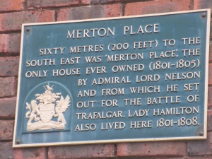
This plaque explains where Merton Place used to stand.
It is hard to work out just where the house might have been but I reckon it is probably somewhere around where these garages now stand, just near a block of flats called “Merton Place”.
Nelson lived in Merton Place after he separated from his wife Fanny in 1801. Nelson shared Merton Place with both Sir William and Lady Emma Hamilton – a somewhat unusual arrangement. Emma Hamilton was the hostess. She had a lavish lifestyle and after Nelson’s death in 1805, she soon ran into debt and Merton Place was sold. The house was demolished in 1823 and the land developed for housing and industry. The grounds of the house were on both sides of Merton High Street and apparently there was a tunnel to link them. There is a little clump of roads to the north of Merton High Street which all have Nelson connected names: Hamilton, Hardy, Nelson, Trafalgar,Victory.
From the High Street, take a left down Pincott Road and at the end you will reach High Path. Turn right. At this junction there is another pub. This one is called the Trafalgar. It is tiny and looks like a real locals’ local (I did not venture in)
Stop 9: St John’s Church, High Path
Just along High Path from the Trafalgar pub on the left is St John’s Church.
This church lies in what were the grounds of Merton Place, but this is not the church Nelson would have gone to – for one very simple reason. It was not even built when he was alive. This church dates from 1913/14 to mark the anniversary of Nelson’s death – a bit late! The altar piece is apparently made from timber taken from HMS Victory and there is some stained glass by pre-Raphaelite artist Edward Burne Jones. Not that you can see this as here is another church which appears hardly ever to be open. It does look very lovely in these pictures. You feel you could almost be in the country but this is deceptive. The other side of the road is much more workaday London – an estate of not very special blocks of flats.
Just past the church on the left is a small garden, go in the gates.
Stop 10: Nelson Gardens
Like the church, this garden is on land donated by the great nephew of Rear Admiral Issac Smith to commemorate the centenary of Nelson’s death. There is a plaque which explains this. It is flanked by two small cannons. These are 12 pounder guns (whatever that means) and are thought to have adorned the lawn of Merton Place at one time.
Rear Admiral Issac Smith is not a name you may have heard of, but he does have an interesting claim to fame. He was a cousin of Captain James Cook’s wife Elizabeth, and Smith accompanied Cook on two voyages of exploration in the South Pacific. Smith was the first European to set foot in eastern Australia and the first to prepare survey maps of various Pacific islands and coastlines including Tierra del Fuego in South America. On his retirement he shared a house in Clapham with Cook’s widow until in the 1820s he inherited Merton Abbey and then until his death in 1831 he split his time between Clapham and Merton.
Continue along High Path and turn left at the end (Morden Road)
Stop 11: the end of Merantun Way
Go a short way along Morden Road and you come to the end of Merantun Way. But look carefully at the road layout.
It it rather odd. The carriageway splits and there is a wide grass verge in the middle. This is because Merantun Way was never finished as intended. The plan was to extend it further along the disused railway track to join Kingston Road thereby bypassing the level crossing on Kingston Road. It would have sliced through Merton Park but it never happened because of local opposition in the late 1980s. That opposition mutated into a strong community group which put up candidates in the borough elections and today Merton Park continues to be represented by independent councillors. This does not usually matter but it has since 2006 because the main parties are so evenly balanced in Merton. So the Merton Park councillors have been the king makers, allowing the Conservatives to run the administration from 2006 until 2010 and then Labour from 2010. It will be interesting to see whether Merton Park councillors will play such a pivotal role following the 2014 elections.
If it is not too muddy you actually walk along the route of the old railway line on the other side of Morden Road from Merantun Way (see picture)
But if it is wet, you can head back past the Staples store and turn left and go down a street called The Path which then leads you into Melbourne Road and then onto an open space. Either way you will end up in the same place a junction of pathways. Here you can take a short diversion following the signs for the Merton Park tram stop.
Stop 11a: former Merton Park station building
This path will lead you to the end of Rutlish Road and there where the traffic has to turn round, there is a building that looks like a station building.
The reason it looks like a station building is because it is the original station house of Merton Park station. The rest of the station is gone and is now just a tram stop with nothing to show that there was actually a railway station here.
Retrace your steps to the path junction and follow the other path (or if you have not made the diversion, take this path)
Go over the tram line and into Merton Park. At the end of the path cross Dorset Road and go down Sheridan Road. When you reach Church Lane, turn left and soon you will reach St Mary’s Church. This is a bit of a trek but it is worth it.
Stop 12: St Mary’s Church
You could almost be in a country village. All that is missing is the village pub (there are no shops or pubs in the Merton Park estate).
Now this is the actual church which Nelson went to and it still has his pew apparently. If you can, go in and see the various memorials as well as stained glass by Burne Jones and Morris and Co made locally at Merton Abbey Mills.
There are a couple of interesting tombs in the graveyard. At the front between the war memorial and the lych gate, is a fairly weathered one, which is of William Rutlish, who was embroider to King Charles II. Presumably this was a well paid trade and Rutlish left money to found a school. Rutlish School still exists just over the border in SW20 as we shall see in the next walk.
And then if you go into the graveyard, you pass by an archway on the right and a fair way in on the left is John Innes’ grave. We will hear more of him in SW20 also.
Returning back to the entrance do have a look at the archway between the churchyard and the vicarage.
This is a norman arch which came originally from Merton “Abbey” and was reconstructed here in 1935, paid for by Gilliat Edward Hatfeild (yes that is the right spelling). Hatfeild was the last owner of nearby Morden Hall Park and it was he who bequeathed that property to the National Trust. However it is over the border in SM4.
We have reached the end of our SW19 walk. Much of the story of this part of London can only be told with the fragments of what is here today and it is kind of sad that more has not survived of this historic part of London.
It seems we are in a country village here by St Mary’s but if you go down Melrose Road and then turn left into Dorset Road you will be at Kingston Road and then Merton Park tram stop in less than 10 minutes. Alternatively there are buses to Wimbledon and South Wimbledon from Kingston Road.


