
SE25 is South Norwood, although if you were to ask most people round here they would probably call the area Norwood Junction after the main station here.
We start our walk at South Norwood Post Office which is 85 -87 High Street inside a Nisa convenience store.
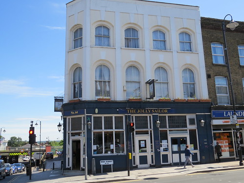
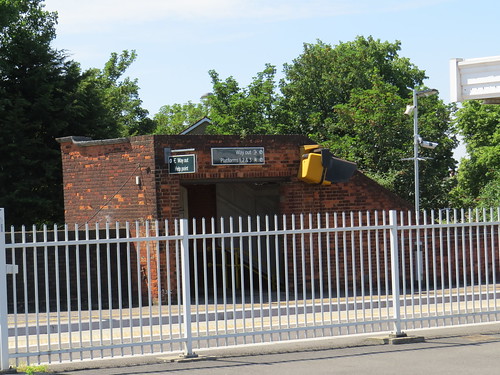
Now turn right out of the shop and our first stop is just a little way along the High Street. It is the pub at the corner with Portland Road.
Stop 1: The Jolly Sailor
The Jolly Sailor looks like a fairly ordinary pub that has seen better days.
But down on the pavement in the High Street. There is a map
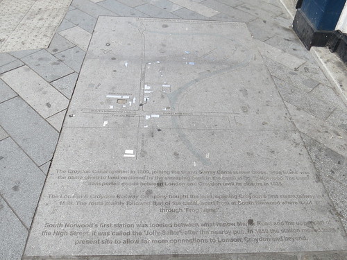
This has not weathered well but at the top it says this is an “1836 map depicting the road layout buildings and canal.”
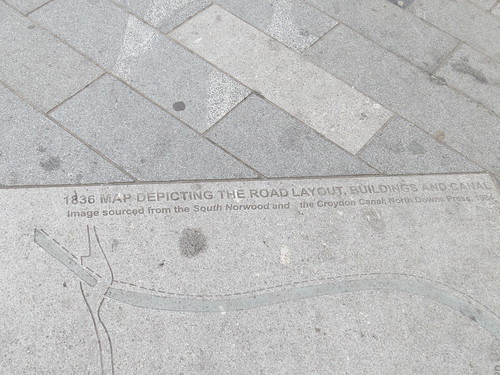
This highlights how things were around here around the time of the closure of the Croydon Canal which had opened in 1809. So it was before the canal was filled in and much of the alignment used for the London and Croydon Railway which opened in 1839
Just around the corner is a local blue plaque to note that this is the site of the Jolly Sailor Inn – South Norwood’s first public building. Note the date is just after the opening of the canal.
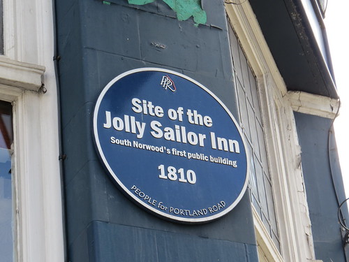
And I should have added that when the railway first came through here the local station was called “The Jolly Sailor”.
Now cross over the High Street and head along South Norwood Hill which is the left turn from the High Street at this cross roads. Our next stop is soon on the right hand side.
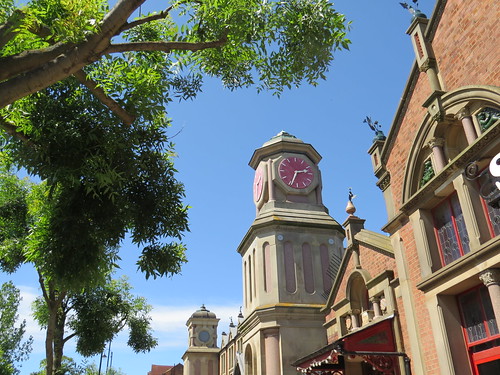
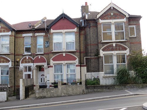
Stop 2: Stanley Halls
There is quite a jumble of early 1900s buildings here on the right hand side of the road.

First you get to Stanley Halls which is a Grade II listed complex of Edwardian buildings built in 1904-11. The Halls include an art gallery, theatre hall and assembly rooms. The building was donated and designed for the people of South Norwood by William Ford Robinson Stanley (1829-1909), a prominent local inventor, industrialist and philanthropist.
The venue is managed The Stanley People’s Initiative, a charity established by the local community to re-open, manage, improve and restore Stanley Halls.
In the first porchway you see, there is an English Heritage plaque to W F R Stanley.

Stanley was largely self-taught. He dedicated Sunday to learning; starting with architecture and theology and moving on to English, astronomy, geology, chemistry, mathematics and French.
In 1854 he set up his own business in Holborn making mathematical and drawing instruments. He invented the t-square, the panoptic stereoscope and a straight line dividing machine. This apparently won first prize in the International Exhibition of 1862 and guaranteed his fortune.
Stanley moved his factory to South Norwood in the mid 1870s. It operated here until 1926 when the company moved to New Eltham. The business survived until 1999 when it went bust.
Interestingly though the Stanley knife is not one of William Stanley’s inventions, nor one of the products made by W F R Stanley’s company. The Stanley knife comes from an american company which for many years was called The Stanley Works. This had been formed by a merger of Stanley’s Bolt Manufactory, founded by Frederick Trent Stanley in 1843, and the Stanley Rule and Level Company, founded by Frederick’s cousin, Henry Stanley, in 1857.
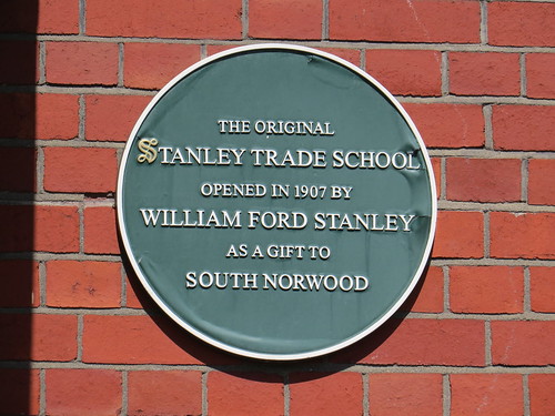
Next door to the Halls is the Trade School. Originally a technical school for 12 – 15 year olds, today it is part of a Harris Academy.
Architectural commentator Pevsner describes the halls and School as “the most memorable buildings in South Norwood … a vigorously eclectic group in red brick and stone with two towers and a series of gabled roof lines adorned with the extraordinary motif of copper flowers in flower pots…The rather ponderous free style (miles away from contemporary Arts and Crafts) relies partly on debased Italianate detail, with long oval panels and pink marble columns as recurrent motifs, but also includes eccentricities such as elliptical arches.”
Pevsner does not quite say this is terrible architecture, nor that it is so bad, it is good. I guess the sub text is basically this not bad for an amateur who does not know what he is doing.
Now go back to the cross roads and keep straight on. This is Portland Road. Go under the railway bridge and look back to the parapet to your left.
Stop 3: The London to Croydon Atmospheric railway
Here you will see a local blue plaque, noting the connection with a strange little footnote in railway history – the Atmospheric Railway. We heard about this in Forest Hill.

The plaque notes that this is near the location of Norwood Pumping Station. These railways had a continuous pipe located centrally between the rails and pumping stations were used to create a vacuum in the pipes. A piston extended downwards from the trains into a slit in the pipe, with trains blown towards the pumping station by atmospheric pressure. The pumping station here was apparently in a Gothic style, with a very tall ornate tower that served both as a chimney and as an exhaust vent for air pumped from the propulsion tube.
One of the issues with the atmospheric railway was that it was not possible to have tracks crossing each other. Thus south of here the railway created one of the first flying junctions to take one line over another and so avoid the problem.
With hindsight one can see that this was a technology doomed to failure, but you have to admire the Victorian spirit of ingenuity.
Now keep walking along Portland Road and our next stop is soon on the right.
Stop 4: site of a Cinema, 44B Portland Road
This modest looking doorway was the entrance to an early cinema.

According to the wonderful Cinema Treasures site, it first opened as the New Electric Theatre in February 1911, then it closed from the time to time and went through various names: the Electric Theatre (1917) the Mascot Cinema (1919), La Rosa Cinema (mid 1920s) and back to the Electric Cinema in 1928. Closed again by 1930, it reopened in 1934 as the Regent Cinema, finally closing in February 1935.
During World War II it became a restaurant, and after the war became a kitchen for preparing school meals. From March 1963, it was converted into a youth club, known as the Socco Cheta Club, offering snooker, television and an activities room. The Socco Cheta Club was closed in 2005, and the building was put up for sale. It does not seem to have any presence now but the Socco Cheta sign is still over the door, so it looks like no one else has taken this building on.
Now continue walking along Portland Road, our next stop is further on the right hand side at the corner of Stanger Road.
Stop 5: site of Picture Palace cinema, 110 Portland Road

This was another early purpose built cinema opened in 1910 as the Central Hall Picture Palace. In design it was almost identical to the Central Hall Picture Palace in Tooting (later the Classic cinema). From the late-1930’s, it was known as the Central Cinema. In 1953, it was became the Rex Cinema and it was closed in 1956.
The building was converted into a reception hall, known as the Portland Room, then it was converted into a furniture showroom. This closed by 2006 and after a couple of years the buildings was redeveloped into eleven flats, which were ready for occupation in June 2009.
Now just past the side turning on the right is our next stop.
Stop 6: Number 118 Portland Road
Notice the rather odd plaque between the first floor windows.
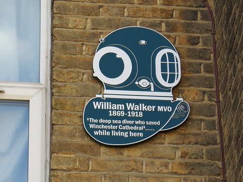
William Walker (1869–1918) was an English diver famous for shoring up the southern and eastern sides of Winchester Cathedral.
In the early 20th century, the cathedral had been in imminent danger of collapse as it sank slowly into the ground, which consisted of peat. The Wikipedia entry explains
“To enable bricklayers to build supporting walls, the groundwater level had to be lowered. Normally, the removal of the groundwater would have caused the collapse of the building. So, to give temporary support to the foundation walls, some 235 pits were dug along the southern and eastern sides of the building, each about six metres deep. Walker went down and shored up the walls by putting concrete underneath them. He worked six hours a day—in complete darkness, because the sediment suspended in the water was impenetrable to light.
Between 1906 and 1911, working in water up to a depth of six metres (20 feet), he shored up Winchester Cathedral, using more than 25,000 bags of concrete, 115,000 concrete blocks, and 900,000 bricks.
After Walker finished his work, the groundwater was pumped out and the concrete he had placed bore the foundation walls. Conventional bricklayers then were able to do their work in the usual way and restore the damaged walls.”
Now return to that side street (Stanger Road() and follow this all the way to the end which will bring you to our next stop.
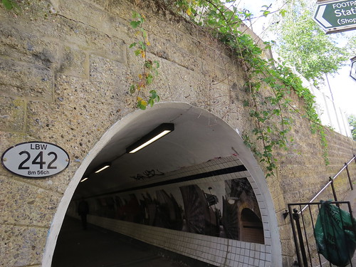
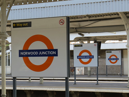
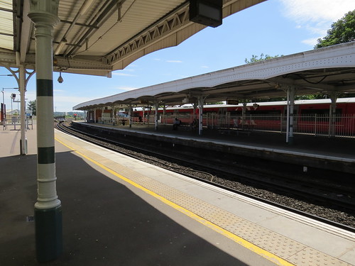
Stop 7: Norwood Junction station
Ahead you will see the secondary entrance to Norwood Junction station. Before we venture into the station, have a look at the local blue plaque.


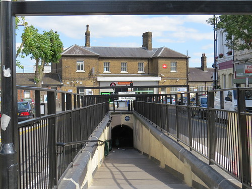
This celebrates that this was the world’s first reinforced concrete underpass, opening in July 1912. I must say I find this a bit surprising. Surely reinforced concrete had been used for tunnels before then.
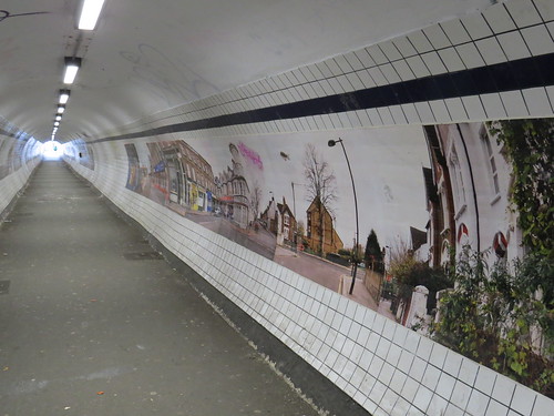
If you go down the steps to the left you can take the underpass to the other side of the station.
An attempt was made a while back to brighten up the walls with photographs of local scenes, but sadly much of this has been damaged.

Norwood Junction station is worth a look.
As already mentioned the first station here opened in 1839 on the London and Croydon Railway and was called Jolly Sailor. It was further up the line from the present station at the north end of the High Street, adjacent to a level crossing. It was renamed Norwood in 1846. Following construction of lines to Crystal Palace that station closed in June 1859 and was replaced by a new station on the current site.
It became Norwood Junction and South Norwood on 1 October 1910 but then just plain Norwood Junction in 1955.
It has platforms numbered 1 to 7. The track serving platform 1 also has a platform face on the other side, which is numbered Platform 2, but trains do not open their doors at that side. Wikipedia says this is due to the live rail being on the side nearest to Platform 2. But interestingly there are places like this on the London Underground, like Morden, where the doors open on both sides. I am not sure that Platform 7 is actually used much.
Now that the station is served by London Overground trains going to West Croydon it has been rebranded and resigned with roundels. Odd really, as most of the trains stopping here are not actually London Overground but Southern or Thameslink.

There is a nice spot on platform 1 where you see three roundels on three different platforms.
The main station building is on platform 1.

As we head away from Norwood Junction station, you will see the subway coming up
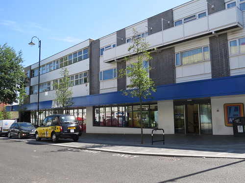
Then ahead, note the Aldi supermarket on the left. This is the site of the Odeon cinema. This opened in July 1937 and was a typical Odeon style with cream tile cladding, with several horizontal bands of jade green Vitrolite tiles and a central window above the entrance with decorative grillework.
The cinema closed in February 1971 never having been split into smaller screens or converted to bingo. The site was redeveloped as a Safeway supermarket and flats. It became a Somerfield and now is an Aldi.
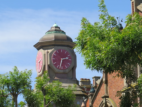
At the end of Station Road, there is a nice clock tower which is our next stop.
Stop 8: The Clock Tower

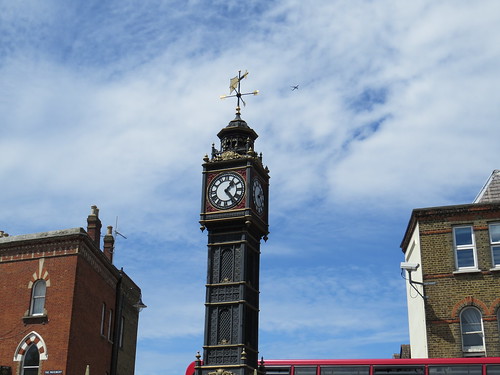
As the sign says this was erected by “the people of South Norwood to commemorate the Golden Wedding anniversary of Mr and Mrs W F Stanley on 22 February 1907”.

Continue along the High Street as if you had turned left out of Station Road. The main road becomes Selhurst Road. Turn right into Park Road. Our next stop is ahead on the left. Stop by the corner of Holmesdale Road.
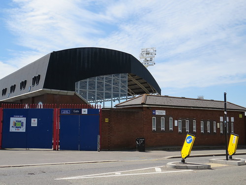
Stop 9: Crystal Palace Football Club
Here we have Crystal Palace Football club, although the main entrance is on the other side in Whitehorse Lane. That is a bit further to walk, so I am planning to stop here.
Although Crystal Palace Football Club is not actually by the site of Crystal Palace, it can trace its roots back to that building.
As we heard in SE19, inside the grounds of the original Crystal Palace is a stadium. This has been rebuilt but in a previous life the stadium was used for football and between 1895 and 1914 it was the home of the FA Cup Final. The Crystal Palace Company who owned the venue, wanted a professional club to play there and tap into the crowd potential of the area. So in 1905, they formed a new club called Crystal Palace F.C., to play at the stadium.
Wikipedia tells me that when the First World War broke out the Palace and grounds were seized by the armed forces, and in 1915 the club were forced to move by the Admiralty. They found a temporary base at the Herne Hill Velodrome. Although other clubs had offered the use of their ground to Palace, the club felt it best to remain as close to their natural catchment area as possible. When Croydon Common F.C. were wound up in 1917, the club took over their old stadium (called the Nest), but in 1919 they began the purchase of the land on which they would eventually build Selhurst Park, which is where we are standing now.

Go back down Park Road and when you reach the main road carry on across the cross roads into Tennison Road. Our next stop is a little way down on the right
Stop 10: Number 12 Tennison Road
At Number 12 you will see there is a blue plaque.
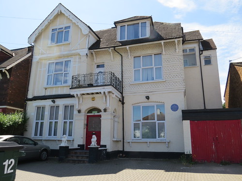
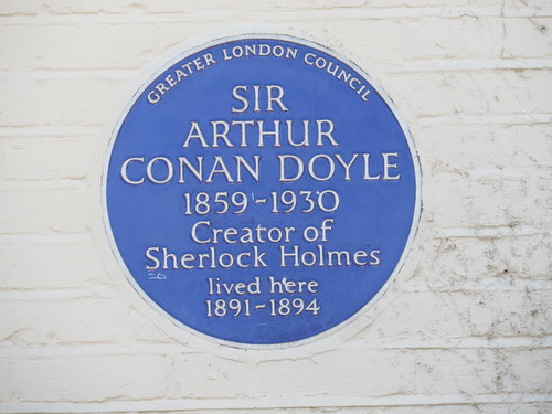
Not just a local one but a proper Greater London Council one and it is for Sir Arthur Conan Doyle (1859 – 1930), the creator of Sherlock Holmes, who lived here from 1891 to 1894..
No doubt the area was somewhat different then. But Conan Doyle had already created Sherlock Holmes by then and published two novels – A Study in Scarlet (1887) and the Sign of Four (1890) and whilst he was living here he wrote a number of the short stories featuring Holmes, initially published in the Strand magazine . The novels were not initially successful and it was the short stories,that made both Holmes and Conan Doyle household names. Once he had such success with Holmes he was clearly able to move away from South Norwood.
Now return to Selhurst Road and turn left. Continue along here and turn right into Dagnall Park a street of rather grand houses. Keep going down Dagnall Park, going under the railway. Our next stop is just after Edith Road on the left.
Stop 11: Number 30 Dagnall Park
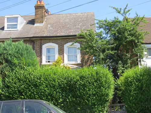
It is hard to see this house and the reason we have stopped here. But if you look carefully through the foliage, you will see a blue plaque.
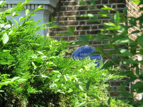
This is to the composer Samuel Coleridge-Taylor (1875 – 1912).
He was mixed-race. His father was a Sierra Leone Creole physician called Daniel Taylor. His mother was called Alice Martin and she was not married to Taylor. She named her son Samuel Coleridge Taylor after the poet Samuel Taylor Coleridge, but without the hyphen. It seems that he adopted the hyphen, following a printer’s typographical error.
Coleridge-Taylor was particularly known for his three cantatas based on the epic poem, Song of Hiawatha by American Henry Wadsworth Longfellow. Unfortunately Coleridge-Taylor sold the rights to Song of Hiawatha outright and so received no royalties.
His situation contributed to the formation in 1914 of the Performing Rights Society which aimed to get revenues for musicians through performance as well as publication and distribution of music.
Now return to Edith Road and turn right. As you walk along you will see the side of Selhurst station, our final stop.
This by the way is the staircase to the platform which serves the London bound fast line and so it is hardly ever used, as fast trains do not normally stop here. It really only gets used in an emergency or when there is engineering work on the slow lines.
At the end of the street turn left and go under the bridge. The entrance to the station is just on the left.
Stop 12: Selhurst station
The line here was opened in 1862 by the London Brighton and South Coast Railway as a more direct route to and from the newly opened Victoria station, thus avoiding Crystal Palace and Norwood Junction. The station here did not however opened until May 1865. The lines were quadrupled in 1903. Pevsner says the station is circa 1900, so I guess it was rebuilt at the time of the quadrupling.

Up at platform level, there are three platforms: one serving outbound slow line and an island platform serving London bound slow line and outbound fast line and a further platform for the London bound fast line. The latter has lost its canopies but they have survived on the other platforms. However the one on the country bound slow line seems to have been shortened.
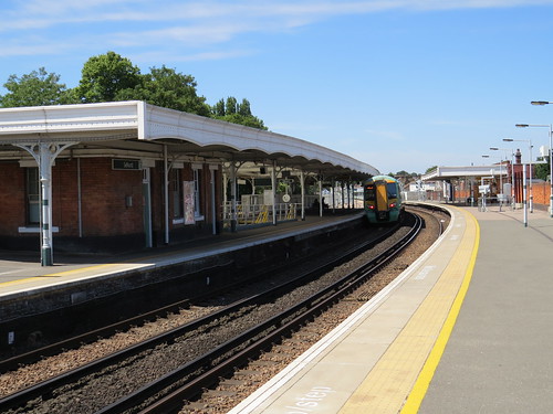
It does at least feel like a proper station, even though the up fast line platform is denuded. You can see the top of that staircase we saw from the street.
Across the road from the station entrance to the entrance to the huge Selhurst depot.

This is built on the site of “the Nest” – Croydon Common F C’s Ground which was later taken over by Crystal Palace F C. By the way it was called the Nest because Croydon Common F C wore red shirts leading them to be known as “The Robins”.
Well that brings us to the end of our SE25 walk. There were some unexpected treasures like the Stanley Halls and the local plaque to William Walker. Plus two “proper” blue plaques to Conan Doyle and Samuel Coleridge-Taylor.
We are now at Selhurst station so this will give you plenty on onward travel options.
