
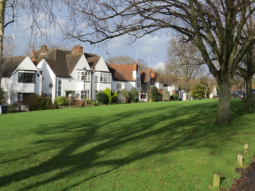
N3 is Finchley Church End according to the Post Office but I think most people would call this area Finchley Central.
When I hear the words Finchley Central I immediately think of that novelty song from 1967 called “Finchley Central”. And then I have to go on and sing “two and sixpence from Golders Green on the Northern Line. It is a kind of an odd song about an odd journey with someone making a date and then being stood up at Finchley Central.
It is by a group called the New Vaudeville Band. This was their follow up to “Winchester Cathedral” which is much in the same vein. Apparently they did not really exist as a performing group initially and only came together properly when Winchester Cathedral became a hit.
I cannot seem to find any vintage footage of the band actually playing, so here is the song with some pictures, old and new, which someone has kindly posted to go with the music on YouTube.
Now we are actually going to start our walk at West Finchley, and the reason is all to do with another tube connection as we shall see.
We start at the Lovesay newsagents at 219 Nether Street which although not a Post Office as such is part of something called “Local Post Office Solution”.

If this is the solution, not sure what the problem is. I guess it provides a few of the sub Post Office services but not the full set.
Turn right out of the shop and almost immediately you will see West Finchley Station
Stop 1: West Finchley Station
Now this is rather like a little country station, especially when you get on to the platforms. Seems wrong to see Northern line trains here.
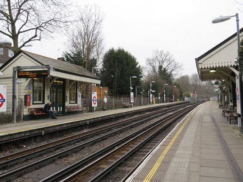
This station is on the branch line that was built from Finchley Central to High Barnet in 1872. But the station itself although it looks quite old was only opened in March 1933.
According to Architectural Historian Pevsner, the fittings for this station came old stations in Northern England – the footbridge for example was from Wintersett and Ryhill, near Barnsley. So maybe this explains why it does not look its age.
The station was there to serve new housing developments and was always just a modest little station. Initially the line was operated by the London and North Eastern Railway (LNER) who presumably had a few bits of spare station up north which they could recycle here. The section of line from East Finchley to High Barnet was incorporated into the London Underground network through the “Northern Heights” project begun in the late 1930s. West Finchley station was first served by Northern line trains on 14 April 1940. LNER service stopped in 1941 and so the station became a station served only by the Underground.
Amazingly this station still has toilets!
Turn left out of the station, go along Nether Street and take the first right which is Courthouse Gardens. Keep to the right hand pavement. You will notice the house numbers go up to the low 30s and then suddenly jump to 64. If you look carefully you will see a street sign which shows we have moved from Courthouse Gardens to Courthouse Road. We have also strayed over the border into N12, but I thought we should come here as we will not able to fit this particular place into our N12 walk and there is an interesting N3 connection. We are looking for Number 60 which is just on the right.
Stop 2: Number 60 Courthouse Road
This house was the home of Harry Beck from 1936 to 1960. He of course is famously credited with creating the iconic tube map in 1933.

And there is even a blue plaque from the Finchley Society.
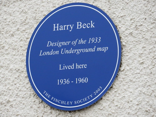
Now here’s a puzzle. When we get to Finchley Central Station, we will see a replica of his map and a plaque saying that Harry Beck used Finchley Central for many years to get to work. Now this does seem strange, given he lived much closer to West Finchley station. Well yes, but for the first few years he lived here, the trains from the relatively new West Finchley station were not Underground trains. They were steam trains which went off to Finsbury Park, so perhaps he just stuck to walking to Finchley Central after the Underground took over.
Return along Courthouse Road/Gardens. Turn right at Nether Street and then take a right into Eversleigh Road. Go to the end and ahead is our next stop.
Stop 3: Former drive to Nether Court
Immediately opposite Eversleigh Road is a gateway and a pathway leading into parkland. This leads on the Finchley Golf Course.
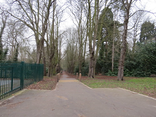
This was once the grand entrance drive to the 15 bedroom home of a wealthy Victorian businessman, Henry Thomas Tubbs. The house, called Nether Court, was built in the early 1880s. He had made his money from knicker elastic.
After his death the house and grounds lay unused for a time but eventually became Finchley Golf Club in 1929, with the house as its clubhouse. Lots of interesting info on the Golf Club website.
http://www.finchleygolfclub.com/club/history/
Now go along Gordon Road as if you had taken a left turn out of Eversleigh Road. As you walk along Gordon Road you will see across the allotments a railway viaduct (our next stop). At the end turn right into Dollis Road and find a place to view the viaduct.
Stop 4: Dollis Brook Viaduct

If you time it right you will see a train go across. And perhaps you will do a double take because it is a Northern line Underground train high up there on that viaduct. It all seems so wrong, but this is another bit of the Northern Line which was built as a “normal” railway. In fact this is the branch line that runs between Finchley Central and Mill Hill East, which is an odd hangover from the Northern Heights project of the 1930s, as we heard in NW7.
Apparently the greatest elevation above the ground level is here on the Northern line at Dollis Brook viaduct over Dollis Road – some 18 metres (60ft) above the ground. But this is not the highest place above sea level. The Underground station highest above sea level is Amersham, at 147 metres (482ft), but I guess there may be a bit of line that is slightly higher
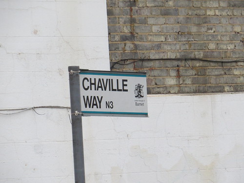
Now retrace your steps along Dollis Road. At the end, do a right into Nether Street. Go over the railway bridge (you will have to cross to the left hand pavement) and continue to the end. At the cross roads, go straight across into Chaville Way, which leads down to Finchley Central station.
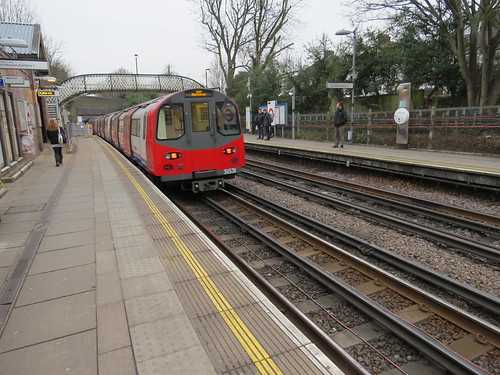
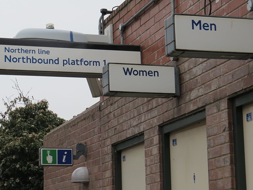
Stop 5: Finchley Central Station
I should just mention in passing that this dull looking road is named after one of Barnet’s twin towns (Chaville is in France). Apparently this road never used to have a name so when they were looking for a name they chose one of the twin towns. Is this the best road, Barnet Council could come up with – not much of a compliment to your twin town is it?
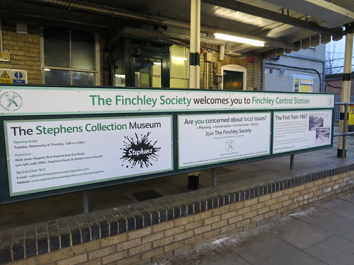
So go down to the station and go onto the nearest platform (the platform for central London) where there are a couple of things to see. First is this board put up by the local amenity society, the Finchley Society. One the left it is advertising the Stephens Collection Museum (we are headed that way soon) and on the right there is a little bit about the first train here in 1867. Very nicely done.
But go along the platform towards the toilets and there is a little plaque to Harry Beck and a copy of his original schematic map of the Underground network.


Now leave the station by the footbridge. Turn left into Station Road, right into Wootton Grove and left into Lichfield Grove. Our next stop is just on the left.
Stop 6: Number 53 Lichfield Grove
This was where the comedian and character actor Terry-Thomas (1911 – 1990) was born. He is best remembered for playing disreputable upper class characters – what were termed “cads” or “bounders”.

His real name was Thomas Terry Hoar Stevens. When he started off as an actor he he billed himself as Thomas (or Thos) Stevens, then he spelt it backwards (Mot Snevets) and moved on to Thomas Terry. He inverted these names when it became apparent that people were mistaking him as a relative of the famous actress Dame Ellen Terry.
Quirkily he added the hyphen in 1947. He is said to have explained that it was “not for snob reasons but to tie the two names together. They didn’t mean much apart; together they made a trade name”.
Continue along Lichfield Grove. Turn right into Sylvan Avenue and at the end go right and soon on the left you will see a gateway into a park. Go in there.
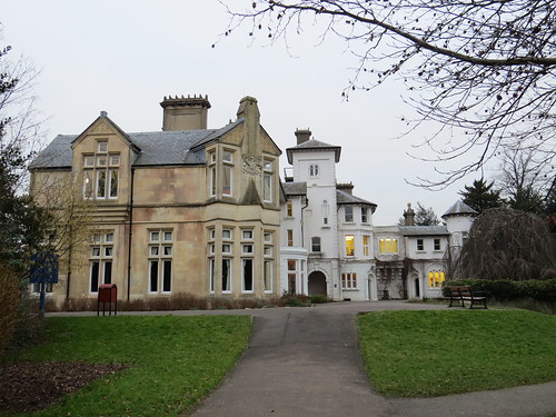
Stop 7: Avenue House and Gardens
You are now in the grounds of Avenue House.
This was the home of Henry Charles Stephens (1841 – 1918). He was known as Inky Stephens. However it was his father Dr Henry Stephens (1796–1864) who invented in 1832 an indelible “blue-black writing fluid” which would become famous as Stephens’ Ink and form the foundation of a successful worldwide company which lasted for over 150 years.
He left the house and grounds to be opened to the public and today they are run by a charitable trust. There is a nice little inky museum in the house. Open three days a week
More info at: http://www.stephenshouseandgardens.com/
Now once in the park, go straight ahead and then after the building called “the Bothy” turn right just before the exit gate. This leads towards the house.
But before we get to the house you will come across a sculpture on the left as you approach the main house. It is of a man sitting on a bench. Not any old man, but it is none other than Spike Milligan.
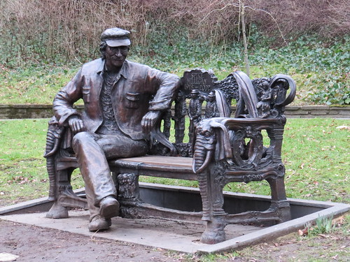
You may ask what he is doing sitting in a public gardens in Finchley.
Well Spike lived in Finchley from 1955 to 1974. When local amenity group, The Finchley Society, was set up in 1971, he was one of the first to join. He became its President and later its Patron.
In 2004, a group of his friends and family combined with The Finchley Society to raise funds for the creation of a bronze statue and here it is.
More info at: http://www.theguardian.com/culture/2014/sep/04/spike-milligan-statue-unveiled-north-london-finchley
Ahead is the house.
Note it has the Finchley motto we heard about in N2 (Regnant Qui Serviunt – He who rules serves)

Now leave the house and grounds and turn right into the street (East End Road). Than turn right into Regents Park Road and continue to the junction with Arcadia Avenue.
Stop 8: Site of New Bohemia Cinema
This very sad looking building is on the site of an old cinema – with the unusual name of the New Bohemia.

The cinema was built in 1920. There had been a cinema called the Bohemia just up the road (in Ballards Lane) but this seems to have lasted only a short time around 1914. So I guess that is why this was the New Bohemia. Curious name for respectable suburban Finchley.
In March 1928, it became part of Gaumont chain and carried on as a cinema for just over 30 years until it was closed in April 1959. Not sure if this ever got renamed. The usually informative Cinema Treasures site is rather light on both these Finchley cinemas and does not even run to an old photograph of either building.
The cinema was replaced by this office block known as Gateway House. Although the ground floor shops are empty now, there is a sign to suggest that Waitrose are opening a small store here.
Now cross the main road and take the road which runs off at an angle to the right (Hendon Lane). Our next stop is just a little way on the right.
Stop 9: St Mary’s Church
This is I guess the Church that gave its name to Church End before the area became better known as Finchley Central.
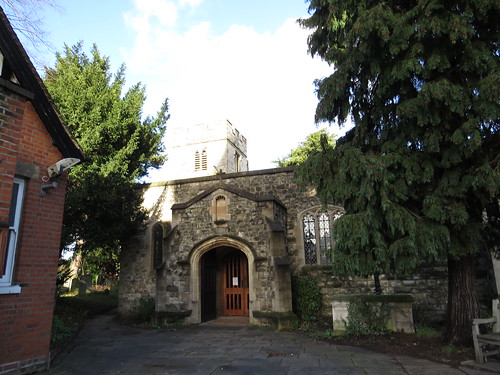
It seems to be the only really old building round here, some of it dating from 15th century, although altered in both the 19th and 20th centuries.

And here tucked away at the side – and looking half forgotten is a seat for the Mayor of Finchley dating from 1933.
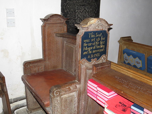
Perhaps a reminder of how different things used to be in local government. I cannot imagine a church installing a special seat for the Mayor these days.
On leaving the church, turn right and then take the second right (Hendon Avenue) and follow this round as it veers to the left. Our next stop is way down the end of this road where you turn left into Village Road.
Stop: 10 Finchley Garden Village
This single street forms Finchley Garden Village, a lovely garden suburb built between 1909 and 1914.

It was designed by a man called Frank Stratton who is commemorated by this memorial. It also serves as a war memorial.

You leave the suburb and the road becomes Cyprus Avenue. Go to the end of this. Then at the main road, turn right, cross over and take the first left (Cyprus Road). Then take the first right (Salisbury Avenue). Go to the end and our next stop is ahead.
Stop 11: College Farm

First you see the entrance, but as you now turn left along Fitzalan Road, you will see a large open space, with a fenced driveway running parallel to you.

This is all College Farm. The website for the farm itself is “being redesigned” but there is quite a lot of info about the shop which seems to be extensive and claims to be North London’s largest equestrian and pet store. Apparently the farm was developed by Express Dairies in the 1880s as what was called a “Model Dairy”. I wonder how it survived the encroaching suburban development.
At the end of Fitzalan Road turn right.
You can look back along the drive of the farm.

Continue to the big road junction ahead of you.
Stop 12: Henlys Corner
This is Henlys Corner, another of those places which is named after some long vanished building – in this case Henlys Garage.

Although the road we have used to approach Henlys Corner is important, it is not as important as the road it crosses here. This road is for a short distance both the A1 (one of the main roads north out of the capital) and the A406 North Circular Road, which is the main orbital route within suburban North London. No wonder it is a so busy.
Just before the junction, though there is an interesting looking sculpture on the green to the right of Regents Park Road as you come to Henlys Corner.

This is called “La Délivrance” by Émile Guillaume and dates from 1920. The statue was created as a celebration of the First Battle of the Marne when the German army was stopped from capturing Paris in August 1914. There were supposed to be 11 copies which were to be offered to cities in France and Belgium. But that does not explain why one is here in Finchley.
In 1920 Guillaume exhibited the statue at the Paris Salon, where it was bought by newspaper magnate Lord Rothermere. Lord Rothermere presented the statue to the Urban District of Finchley. Finchley Council intended that this would serve as a war memorial and be placed at the main entrance of Victoria Park, which is just off Ballards Lane. Lord Rothermere did not like this and told the Council that it could only have it if was placed at its present location. This was so that he might see it when driving to visit his mother, who lived at Totteridge.
And that is why there is a French statue sitting on a green by Henlys Corner.
That brings us to the end of N3, which proved quite a mix. I have to say that I was a little disappointed to discover that there was not much of a centre to Finchley Central. But there were some interesting connections what with Harry Beck and Inky Stephens.
You are now between Finchley Central and Golders Green, slightly nearer the former. Probably easiest to get a bus to either station for onward travel. Indeed if the hapless singer of the song “Finchley Central” had researched his travel options properly, he would not have gone 10 long station on the Northern line via Camden Town. He would probably have found it quicker to hop on a bus which goes a more direct route, but then we would not have this wonderful mad song!

Great page! 4 Courthouse Gardens N3 was my home aged 0-24 so I know very well that Courthouse Gardens is continuous with Courthouse Road but changes from Gardens to Road at the N3/N12 boundary (as you correctly point out). The end of our garden was up the embankment that takes Nether St over the railway by West Finchley station . My mother first lived at No4 aged 8 when it was new in 1926 .
Another place of interest which you walk past in your tour going down Eversleigh Road is the 2ndn childhood home of Terry-Thomas. He was born at 53 Lichfield Grove (as you say) but aged 8 to 21 the family lived at 53 Eversleigh Road (curiously the same house number!). He would often walk along Nether St to go and entertain his young cousins (my mother and sisters) at 4 Courthouse Gardens,
Hi Stephen, thanks for your very interesting article. Although I live in Finchley Church End, The Bohemia in N12 is my local. Having been told by many people that the pub used to be a cinema, i asked the owner if that was true. He said no, and he suggested that I Google Bohemia Cinema to find out the history and location of the original movie house. I was surprised to learn that it used to be situated on the corner of Regents Park Road and Arcadia Avenue, which is the street I live on!
The site is now home to a Little Waitrose and the new Finchley Central library.
What a great read – have lived in N3 for over 50 years and still learnt things about the area I did not know. Have read through some of the blogs on surrounding areas which I have found fascinating. Glad I found your blog and will follow with interest.
Thanks for your comments. Glad you enjoyed reading my blog.
Thanks for this Stephen. As a young child in the 1950s it was our treat to go to College Farm to watch the cows being milked, which I think carried on through to the late 60s or even later. I think a key building that merits a mention is the original Christ’s College Finchley building on Hendon Lane at Church End, and whose copper topped tower can be seen for miles. (The buildings now host a Jewish primary and grammar school, with the college having moved to East Finchley N2 in 1991.) Opened in 1857 by the rector of Finchley, the school has had some interesting ‘old boys’, including the man who introduced rugby to New Zealand, the Saachi brothers (of advertising fame), and former chief rabbi Lord Jonathan Sacks. I went there in 1961. I was living on the Hendon Way (NW2) at the time and walked up to Cricklewood Lane to catch the 645 or 660 trolley bus to Finchley, Sadly, after just one term the trolleybuses were replaced by brand new Routemasters and the routes were renumbered 245 and 260. Although we could have school meals for one shilling (5p) per day many of us would buy a sixpenny bag of chips and a tuppeny iced bun from the shops nearby, meaning that you could save four pennies (1.5p) a day for sweets. The school playing fields were between Lyndhurst Gardens and Dollis Brook, from where one could see the London Transport ‘steam’ locomotive (!) hauling a goods train across the Dollis Brook viaduct all the way to Edgware – the passenger trains, made up of the 1938 Tube stock only went as far as Mill Hill East. It all feels so recent.
Hello, Stephen. We enjoy adding to our local knowledge and were pleased to learn so much about our postal area from your blog post. The Terry-Thomas fact was new to us. We hope that as you walked along Lichfield Grove (not Gardens), you were also aware of the other significant birth that happened there: Private John Parr.
Thanks for your comments. Glad you like the blog. Yes I was walking along Lichfield Grove. I keep meaning to fix that!
I had heard of Private Parr but in connection with Lodge Lane N12 where he lived most of his life, rather than here as his birthplace.
Another point of interest about Lichfield Grove is that it hosted the very first GPO/Royal Mail lamppost mounted posting box, outside no 47, so just three houses along from Terry Thomas’ (further details from Farrugia Young, J. ‘The Letter Box’, Centaur Press, 1969)
That postbox experiment was in September 1896.