NW10: All generalisations are false – including this one.

NW10 covers Willesden, Harlesden, Kensal Rise and of course Kensal Green, of cemetery fame. The latter does straddles the NW10/W10 border and so we covered that in W10, given the entrance we used was in W10.

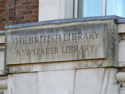
We start in Harlesden at the Royal Mail office for NW10 which is at Numbers 32 – 44 Station Road.

Turn right and walk along Station Road. Soon ahead beyond the junction with Tubbs Lane and Old Oak Lane, you will see our first stop just down Station Approach.

IMG_0504

This is Willesden Junction station, which is a bit confusing as we started in Harlesden and Station Road does not lead to Harlesden station.

Stop 1: Willesden Junction station

The first station here was built in 1866 on the main London – Birmingham line replacing an earlier Willesden station (which is close to where the current Harlesden station now is).

A high level station was built by the North London Railway in 1869, and a little north of the main line, a new low level station opened in 1916 for the local services between Watford Junction and Euston (the so-called Watford DC line, as it was electrified in the 1920s using a direct current electrical supply) and the Bakerloo line.

The platforms on the main line were taken out as part of the overhead electrification of the West Coast main line in the early 1960s.

All this makes for a rather unsatisfactory station with an eccentric layout: Three low level platforms for Bakerloo line and the Watford DC trains (now the London Overground service between Euston and Watford Junction) and two high level platforms on the old North London Line (now London Overground’s Richmond/Clapham Junction – Stratford service).

And some seemingly random passageways joining the various bits up. This picture is taken from one of the walkways within the station.

IMG_0499

I notice that even the signs on the platform kind of hint that maybe this is not actually Willesden.

IMG_0495

Retrace your steps along Station Road to the end. Our next stop is at the junction on the right.

Stop 2: All Souls Church

This church is unusual. Quite unenglish.

It is an octagonal brick structure and as architectural historian Pevsner says this is more a plan associated with non-conformist churches. Apparently the plan derives from Rhineland late Romanesque period. The church was extended in 1890 but this bit was demolished in 1978.

IMG_0514

And just by the door is a little plaque denoting that Princess Margaret came for the centenary celebrations in 1979 – Pevsner says the church dates from 1875/76, so perhaps it took some time to get consecrated.

IMG_0510

Interesting that one of the suffragan (or  “assistant”) bishops in the diocese of London is called Willesden. I think this may be a recognition that from 14th to 16th centuries, Willesden was a place of pilgrimage because of two ancient statues of the Virgin Mary at the Church of St Mary. And in the 21st Century a new shrine has been created .http://www.shrineofmary.org/#!shrine/c1xu8

Sadly St Mary’s is not on our route today, but I thought I would mention it as we were by a church.

Cross the main road and stop at the corner of the pedestrianised area.

Stop 3: (site of) Clock Tower

A Jubilee Clock was erected here in 1888 to commemorate Queen Victoria’s Jubilee the previous year. It was made out of cast iron and cost £299. However it is not actually in place (so far as I could see). It should be at the start of this pedestrianised area. Brent Council are redoing the High Street and seemed to have moved the clock – presumably for safe keeping.

IMG_0516

Go along the pedestrianised street and out next stop is soon on the right.

Stop 4: The Shawl pub

IMG_0517

This Irish pub looks like it could have been a cinema, but the wonderful Cinema Treasures site does not have it listed amongst the 8 building which were used as cinemas in Harlesden.

But a bit of research suggests that this was actually a Methodist Church.

http://commons.wikimedia.org/wiki/File:%27The_Shawl%27,_Harlesden_-_geograph.org.uk_-_1181272.jpg

You can just about see that. Not sure what the founding fathers of this church would have made of it becoming a drinking establishment.

Keep walking along the High Street

Stop 5: The Wig Shop

What is noticeable about this shopping street is the almost complete absence of national chain stores. Even Boots which is on practically everywhere does not have a shop here.

One shop that caught my eye was this one. It is actually three shops together and seems to specialise in hair products for black women. But what is so striking is this extensive range of wigs in the window. There is something rather spooky about this display.

IMG_0525

Continue walking along the main shopping street which becomes Craven Park Road. Our next stop is at the junction of St Albans Road on the left.

Stop 6: Odeon Court, Craven Park Road

IMG_0529

Here on the corner of St Albans Road was of Oscar Deutsch’s Odeon cinemas – opened in July 1937 and seating just over 1700 people. It had a facade was dominated by a large square tower feature faced in cream faiance tiles and edged in brick.

It closed as a regular cinema in April 1972. It re-opened as an Asian cinema screening Bollywood films  under the name Liberty Cinema but soon became a rock concert venue called the Roxy Theatre.

By the 1980s it had become a nightclub called the Tara. After that closed in the mid 1980s, the building was left empty and derelict, finally being demolished in August/September 1989, to be replaced by a development of flats called Odeon Court.

IMG_0528

Retrace your steps back alomg the shopping street and turn left into Tavistock Road, where our next stop is on the right

Stop 7: Tavistock Hall

Now NW10 does not appear to have any “proper” blue plaques – ie the ones which English Heritage (or the GLC or LCC) put up.

But NW10 does have some “local” blue plaques and here on the Tavistock Hall is one of them. This commemorates the “UK’s first Roots Reggae Band” who were called the Cimerons. Not a name I recognise but then I am not really that interested in reggae music.

IMG_0532

IMG_0531

Go to the end of Tavistock Road and turn right into Manor Park Road. Our next stop is just before the end on the left.

Stop 8: former Coliseum cinema (Numbers 25-26 Manor Park Road)

This building was an old cinema – opened in 1912 as the Picture Theatre, it became the Picture Coliseum in 1915.

IMG_0540

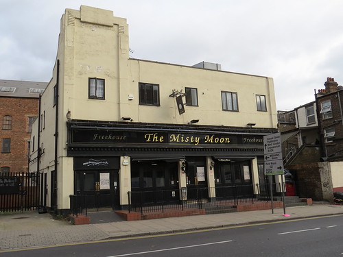
It closed as a regular cinema in December 1975 and then spent its twilight years showing adult porn films and kung-fu movies. It closed in the mid-1980’s but was reborn as Weatherspoon’s pub in March 1993 called ‘The Coliseum’. It apparently retained many features of its cinematic past and had a huge painted mural of Gary Cooper and Merle Oberon in “The Cowboy and the Lady” where the screen used to be.

However Weatherspoon’s closed the pub (so it is not just chain stores who seems to have given up on Harlesden). It became an independent bar named ‘The Misty Moon’. As of December 2014, the pub is closed but a reopening is promised according to the signs.

At the cross roads, continue straight across. Confusingly this is High Street Harlesden. A little way along on the right is a Paddy Power bookmakers (one big chain that has not abandoned Harlesden – wonder why.)

Stop 9:  Number 120 High Street – site of Picardy cinema

This is the site of another old cinema which was known as the Harlesden Cinema Theatre when it opened in December 1911.
IMG_0544
According to the wonderful Cinema Treasures website, it had several unusual features: it had the screen at the entrance end of the building and the auditorium was built with a slight bend.
Around 1930, it was equipped for talkies and due to the position of the screen against the front wall of the building, the speakers were located behind grilles on each side of the proscenium. The cinema was also refurbished, which included a new Art Deco style facade.

It was renamed Picardy Cinema in 1935 and finally closed in October 1957. It then found other uses: an Irish dance hall, a nightclub and finally a snooker club. It was demolished in the spring of 2003 and replaced by this undistinguished building with a Paddy Power Bookmakers at street level and flats above.

Continue walking along the High Street and soon on the left you will see a large office block, containing the local Job Centre Plus.

Stop 10: Harlesden House, Numbers 161-163 High Street

For just 33 years, this was the location of the Willesden Hippodrome theatre.
IMG_0546
Confusingly it was located in Harlesden, although we are not too far from Willesden Junction Railway Station. It opened as a music hall/variety theatre in September 1907 and was designed by noted theatre architect Frank Matcham,  It has a brief flirtation in 1927/28 with a mix of cinema and variety, but went back to live theatre use in January 1929.

It was taken over by Associated British Cinemas (ABC) in August 1930. It became a full time cinema until September 1938. It then re-opened as a music hall/variety theatre, with films shown on Sundays, when live performances were prohibited.

The Willesden Hippodrome Theatre was destroyed by German bombs in August/September 1940. The remains of the building stood on the High Street for many years. It was finally demolished in 1957. In the 1960s an office block called Harlesden House was built on the site. It was once the Labour Exchange but now houses Job Centre Plus.

As ever, the Arthur Lloyd site was the source of this info and also has a couple of nice exterior shots of the old building: http://www.arthurlloyd.co.uk/WillesdenHippodrome.htm

Continue walking along the High Street and turn left into Furness Road and then right into Wrottesley Road. Our next stop is on the right just before the little roundabout.

Stop 11: Number 8 Wrotessley Road

This modest looking house boasts another one of the local Blue Plaques.

IMG_0549

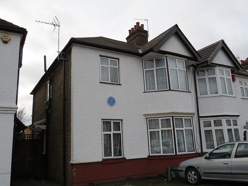
This honours Liz Mitchell who was regarded as the voice of 1970s disco group Boney M.

IMG_0548

Boney M. was created by German record producer Frank Farian. Originally based in Germany, the four original members of the group’s official line-up were Jamaican-born singers Liz Mitchell and Marcia Barrett, Maizie Williams from Montserrat and Bobby Farrell from Aruba. The group was formed in 1976 and achieved popularity during the disco era of the late 1970s. Since the 1980s, there have been various line-ups of the band with different personnel, and there have apparently been some disputes about ownership of the name. Liz Mitchell continued to perform in the 21st century, billed as Boney M. featuring Liz Mitchell.

At the little roundabout go clockwise round the roundabout and take the second road on the left. Confusingly although the street you have just crossed is called All Souls Avenue, the church is called something completely different. (presumably the road is called All Souls because the land round here was owned by All Souls College, Oxford.)

This is Bathurst Gardens. It is quite a walk to our final stop which is just at the corner of College Road.

Stop 12: Former Kensal Rise Library

IMG_0554

IMG_0557

All libraries will end up like this. And all generalisations are false, including this one.

This by the way was Kensal Rise Library. It was opened by Mark Twain in September 1900 and closed a couple of years ago. And in case you have not guessed it, the quote about all generalisations is often attributed to him, although others including Voltaire or Alexandre Dumas have been credited with it.

There was an extensive campaign to save this library. It has had widespread support not just from the local community and the national press, but also various well known people including Alan Bennett, Jacqueline Wilson, Philip Pullman, Zadie Smith.

However it does look like they have not succeeded to keep the library intact. There is a planning application under consideration to convert most of the building to residential use, although a small part would be reserved for community use.

More at: http://www.savekensalriselibrary.org/about/#sthash.8zdO4UVy.dpuf

So that brings us to the end of the NW10 walk. Shame I could not fit in the Capital City Academy which opened in 2003 with building designed by Norman Foster. It is a successor school to Willesden High School which itself had been Willesden Grammar School. Alumni include Thunderbirds puppeteer, Gerry Anderson and actor Shane Ritchie. Old “boys” of the school go by the name “Old Uffs” presumably on account of the fact that the first school was on Uffington Road. They have their very own website:

http://www.olduffs.org/ou/FamousOldUffs.htm

I also could not visit Park Royal – home to many famous names like McVitie’s Biscuits and Heinz and formerly the location of Guinness’ brewery in the UK.

And we never did get to Willesden proper, and the shrine of our Lady of Willesden.

But then again we cannot see everything in a postcode.

For onward travel go down College Road (a right turn from Bathurst Gardens).

Note the old street signs with just the NW – although unlike the ones elsewhere these have the background in black and the name in white. And note also at some point in the past someone has helpfully added a “10” so that you know this is NW 10. Presumably this was cheaper than putting up a new sign!

IMG_0559

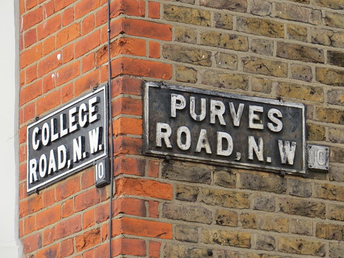
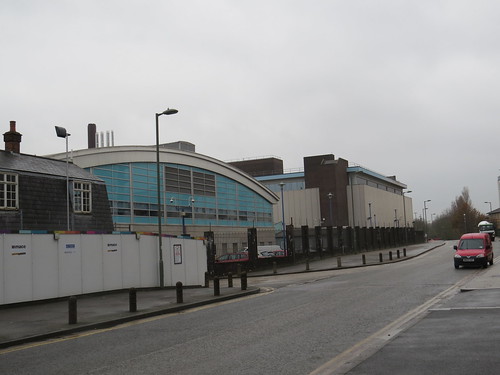
And after a short walk you will reach Kensal Green station, which is just about where we ended the W10 walk.

Postscript

Kensal Green station originally opened in 1916 but building here is fairly modern dating from 1980.

IMG_0563

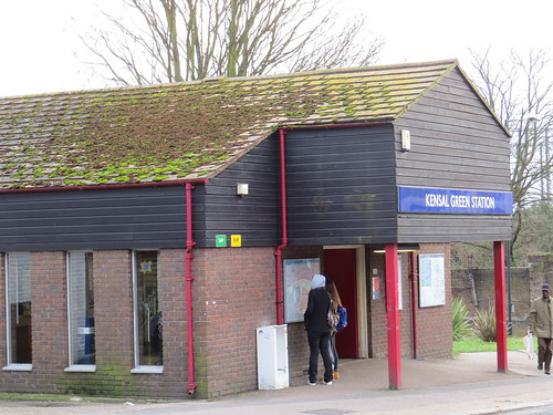
It looks like it has a green roof – or perhaps not. It maybe just a little overgrown.

NW9: Hyde and seek

NW9 is officially called “The Hyde” by the Post Office. Where? I hear you say.

IMG_9830

Hardly anyone will have heard of The Hyde so we will go and seek the places people might have heard of in NW9 , such as Colindale and Kingsbury.

We start with Kingsbury, at the Post Office, at 439 – 441 Kingsbury Road. Turn left out of the Post Office and soon our first stop is on the left.

Stop 1: Kingsbury station

Kingsbury station was the catalyst for development here in the 1930s.

IMG_9942

The station was built by the Metropolitan Railway as part of their new branch to Stanmore and opened in December 1932, just before the creation of London Transport in 1933. This then became the Metropolitan line under London Transport.

As we heard in NW8 additional tracks were added to give more capacity between Finchley Road and Baker Street. And it was the Stanmore branch trains which went into the new tunnels and became a branch of the Bakerloo line. So Kingsbury became a Bakerloo line station from 1939. It was then transferred to the Jubilee line when that opened in 1979.

The design of this station looks like an overgrown country cottage and is very much the style adopted by the Metropolitan Railway. How very different from the other stations built around this time by the Underground company and by the Southern Railway which were much more modern in style, using concrete and glass. And how very different from the rest of the street on either side which consists of typical 1930s parades of shops.

Our next stop is almost immediately across the road.

Stop 2: site of Kingsbury’s Odeon cinema

Today you see an Aldi supermarket flanked by two small shop with creamy tiling, but this was the site of the Kinsgbury Odeon.

IMG_9940

It was built for and operated by Oscar Deutsch’s Odeon chain, opening in May 1934. It seated 724 in the stalls and 279 in the balcony.

It was renamed the Gaumont in 1950, presumably as there were quite a few other Odeons locally. But it reverted to the Odeon name in 1964 and finally closed in September 1972.

The auditorium, foyer and main entrance facade were demolished and replaced by a Sainsbury’s supermarket. And today this is now Aldi. But the ghost of the old building survives in the form of two original shop units on either side.

Now walk back along Kingsbury Road and when the shops run out you will see a park ahead which includes a little children’s play area. Our next stop is just behind that play area.

Stop 3: Roe Green Park

We are specifically going to a building just inside the park. It used to be something called the Veteran’s Club but is currently being refurbished as a Children’s nursery.

IMG_9839

And here just by the front door is a little plaque erected by the Borough of Wembley, commemorating that this is where John Logie Baird experimented with sending television signals in 1929.

IMG_9836

As of now you can get right up to the door to see the plaque but I guess that might be more difficult when it becomes a nursery. This by the way seems to be the nearest NW9 gets to having a blue plaque!

There is also a stone tablet commemorating the same connection put up y the Wembley History Society

IMG_9838

But it is quite hard to read!

Now we are going to Colindale which is a bit of a walk, so I suggest you hop on a 204 bus. Return to the main road and there is a stop called Valley Drive just near here. After about 6 stops you will be at The Hyde (the stop to get off at is called Colindeep Lane).

You can walk if you really want. Go along Kingsbury Road, turn left into Roe Green and then right at the roundabout into Hay Lane. The Hyde is over the hill at the end of Hay Lane.

From the bus stop walk back along the main road. If you have walked turn right at the end of Hay Lane.

Stop 4: Another former Odeon cinema

This is in the distinctive Odeon cinema style and indeed it was opened in January 1935 by Oscar Deutsch as part of his Odeon chain – just down the road from Kingsbury where the Odeon had opened the previous year.

IMG_9827

It is unusual in that it has a long facade with a wide central recessed entrance with shop units on each side with flats above. It even had a car park at the rear.

You feel that it ought to have a tower but apparently it never did. Inside seating was provided in a semi-stadium plan with 726 seats in the stalls and 279 in a raised balcony area which did not overhang the stalls.

This Odeon was closed in September 1960. It was empty for many years but was re-opened by an independent operator in November 1967 as the Curzon Cinema. It was taken over by Classic Cinemas and renamed Classic Cinema in January 1972. Having been split into two cinemas in 1973, it finally closed in July 1981.

After laying empty for a few more years, the building became the Colindale Snooker Club in 1986. And it remains a snooker club today.

And you can see it as a fleeting image of the Snooker Club in the video for George Michael’s 2004 song “Round Here” at about 1 minute 52 seconds. Don’t blink or you will miss it.

This song is about George Michael’s childhood and how he remembers his first day at school. Although he was born in East Finchley, the family moved to Kingsbury soon after his birth and so George Michael spent a lot of his childhood in Kingsbury.

The words of this song actually reference a place called “Kingsbury Park” but I think this may actually be Roe Green Park – which apparently also features briefly in this video.

However the family moved to Bushey when George was a young teenager and it was here he met Andrew Ridgeley and formed Wham!. Wonder what would have happened if the family had stayed in Kingsbury.

Turn back and go along Edgware Road (or it may be “The Hyde”, not too sure). Just after the junction with Grove Park, there is a large building site, which is our next stop.

Stop 5: Former Oriental City shopping centre

This was the location of a rather unusual shopping centre called “Oriental City”.

IMG_9831

This had been originally developed by a Japanese company called Yaohan but when they went bankrupt in the late 1990s, it was sold to a group of Malaysian businessmen who restyled it as the “Oriental City” shopping centre. As the name suggests it specialised in selling oriental goods with a food court and a supermarket. It was sold again in 2006 and plans were made to redevelop it as a B & Q store and housing.

After much protest, it finally closed in 2008 but nothing much happened. There was an attempt to restart the shopping centre with some of the former tenants but this got nowhere.

Finally a new scheme came forward and was approved in 2013. The site was cleared for development in the summer of 2014 and the plan now is to have a Morrison’s supermarket on the site with housing.

Now cross the road and search out Merit House, which is a twelve story office block clad in shiny glass.

Stop 6: Merit House (site of former tram and trolley bus depot)

The anonymous looking block called Merit House at 508 Edgware Road occupies the site of the Metropolitan Electric Tramways Depot.

IMG_9946

Here in 1910, the first trials in Britain of a trolleybus took place and then the depot became a trolleybus garage in 1936. It had been intended to convert all tram routes to trolleybuses but the war intervened and after the war it was decided to standardise with diesel motor buses.

The garage name was changed to Colindale in 1950 to avoid confusion with nearby Hendon bus garage.  With the abandonment of trolleybuses, it was closed and then demolished in 1962. In fact the land behind the depot was used from 1959 to 1962 by the George Cohen 600 Group for scrapping London’s trolleybus fleet which numbered almost 1900 vehicles.

So this site represents both the birth and death of the trolleybus in London.

The building is currently under renovation and looks set to become the new headquarters for an organisation called “Utility Warehouse” which is a company that specialises in selling broadband, phone and energy supply packages.

IMG_9951

Now walk back along Edgware Road and turn left into Colindale Avenue. 

We cross a little bridge over the delightfully named Silk Stream. Sadly it does not look as lovely as its name.

IMG_9952

After the entrance to the Public Health England site on your left, watch out for the terrace of houses on the left with this nice little plaque (it is above the doors to 117 – 123)

IMG_9955

Not sure how old this is. But maybe it is not so old and was because a couple called Colin and Linda lived here.

Our next stop is ahead just across the road

Stop 7: Former Newspaper Library

This building was until 2013 the Newspapers section of the British Library.

IMG_9956

The British Library first came to Colindale in 1902 when they built a new depository. The building was expanded in the early 1930s and became the newspaper library in 1934. The older part of the building was destroyed by bombing in 1940 and was rebuilt in the mid 1950s.

IMG_9958

The Library has an almost complete collection of British and Irish newspapers since 1840, although London editions of national daily and Sunday newspapers are complete back to 1801. The collection is now being made available on line (although it is not free and they still have a long way to go before the whole collection is accessible on line)

http://www.britishnewspaperarchive.co.uk/?gclid=CjwKEAiAkpCkBRCtstKQo5ia5nESJACsCikRkX54OIJoxwi3slbUsqylwrxr0hrq2k11KpGlx0OD5xoCgqrw_wcB

The physical collection is now divided between the British Library sites at St Pancras in London and Boston Spa in Yorkshire.

This site looks like it is going to be another housing development.

Stop 8: Pulse (a new housing development)

The land almost opposite the former British Library Newspaper Library is already in the process of being redeveloped. This new development is called “Pulse” and guess what – it is on the site of an old Hospital.

IMG_9966

Colindale Hospital was opened in 1898 as the “Sick Asylum for the Central London District”. In 1907 the Government began to use the site for making vaccines. It closed as a hospital in the 1990s, but as we saw some offices of Public Health England are still located here. I think that was actually built as the Blood Transfusion Centre administrative offices in about 1990.

But the hospital site proper is still in the process of being developed.

If you venture into the estate you will find one old building (it is identified by the letter LB on the plan – which I guess means “Listed Building!)

It is actually called Jenner Court. Edward Jenner (1749 – 1823) pioneered smallpox vaccine, the world’s first vaccine, so that is clearly the reason. He could not have worked here, given he had been dead over 75 years by the time the site was used as a hospital.

IMG_9963

And you can round the back and see this little courtyard

IMG_9965

When I was taking this picture, a workman doing something with waste bins came up to me and said: “Nice aren’t they. Even the one which is where the Mortuary was.”

Retrace your steps to the main road and turn left.

Stop 9: Colindale Station

The station opened on 18 August 1924 on the north side of Colindale Avenue, on what was then the ‘Hampstead and Highgate Line’ extension to Edgware. The platforms are located underneath the road, on both sides of the bridge.

The original station, a classical style building designed by Underground Architect Stanley Heaps, was severely damaged during the Blitz in September 1940. A simple temporary timber structure was built after the bombing and this was only replaced in 1962. The station has been rebuilt again fairly recently.

IMG_9793

Fascinating fact: T. E. Lawrence (better known as Lawrence of Arabia) regularly used the station when he was stationed at the nearby Hendon Aerodrome and apparently he used the pen name “Colin Dale” in articles he wrote for The Spectator during 1927 and 1928.

Keep walking along Colindale Avenue until you get to the roundabout and here take the right hand road.

The area ahead of you was once Hendon Aerodrome. It was used for aviation from 1908 until the 1960s. The site of the aerodrome is now occupied by the Grahame Park housing estate, Hendon Police College and the RAF Museum.

In 1911 a man called Claude Grahame-White established a flying school here. The Aerodrome was “lent” to the Admiralty  in 1916 and eventually taken over by the RAF in 1919. After a protracted legal battle, the RAF bought Grahame-White’s aerodrome in 1925.

Hendon Aerodrome later became RAF Hendon. After flying ceased there in the 1960s it was largely but not completely redeveloped as a housing estate which was named Grahame Park after Grahame-White.

IMG_9818

Walk along Aerodrome Road and on your right is the site of the Police College which is undergoing a massive redevelopment at the moment.

Stop 10: Hendon Police College (The Peel Centre)

The Peel Centre is the main training establsihment for London’s Metropolitan Police Service.

It was originally called the Metropolitan Police College when it first opened in 1934, to train the “officer” class. It closed in September 1939. After the war, there was some debate about whether it should reopen, as in 1948 a National Police College was established in the Midlands. However it did but as the Metropolitan Police Training School for all levels.

When the Royal Air Force left Hendon in the 1960s, it was decided to rebuild the college. The new colllege was called the Peel Centre, named after Sir Robert Peel. It was opened by HM the Queen on 31 May 1974, forty years to the day after her uncle (the future King Edward VIII) opened the original Metropolitan Police College.

IMG_9803

Along Aerodrome Road within what now seems to be the college site, there is on the right an intriguing looking building with an interesting sculptural frieze. But there is no sign to indicate what was here and why there is this frieze.

IMG_9798

But there is this sign on one of the doors.

IMG_9799

This must have been the works of Franco Illuminated Signs. They opened on Aerodrome Road in 1922. They had made the lights for the Franco British Exhibition of 1908 and the company name was later abbreviated to ‘Franco’. They were also known for the neon signs found in Piccadilly from the 1920s to the 1970s. But sadly there seems to be no recognition of their existence here except perhaps this little substation sign.

Across the road is a new development called Beaufort Park for reasons I have not been able to establish. Go down Heritage Avenue which is the main road through the estate.

Stop 11: Beaufort Park

This is a new development was apparently built on part of the RAF site . It looks decidedly unenglish, more like the kind of things you see in Spain.

IMG_9804

In fact the advertising at the site does mention a “Mediteranean Style Boulevard”. Sadly though they cannot promise mediterranean style sunshine!

IMG_9813

But weirdly, the developers have chosen to call this main “boulevard” across the estate “Heritage Avenue”

IMG_9808

A distinct lack of imagination displayed here.

At the end of Heritage Avenue turn right and our next stop is ahead on the right.

Stop 12: RAF Museum

The Royal Air Force Museum London is also located on the former Hendon Aerodrome. It is dedicated to the history of aviation and the Royal Air Force.

IMG_9816

The museum here was officially opened by HM The Queen on 15 November 1972.

An original World War I Grahame-White aircraft factory hangar was relocated a few years ago to the RAF Museum. This houses the museum’s World War I collection and is named the Grahame White Factory.

So we are now at the end of our NW9 walk. It has proved to be a more interesting area than at first it might have seemed. It has its transport heritage. Not just the former aerodrome and today the RAF museum but also the role it played at the beginning and end of the trolleybus in London. We also saw how it was until recently the home of the vast national newspaper archive and learned of its role in the early production of vaccines.

Return to Colindale station for onward travel. Go back along Grahame Park Road and at the roundabout take Colindale Avenue to reach the station.