N18: No Angel

N18 is Upper Edmonton which is squeezed between N9 Lower Edmonton and N17 Tottenham.

We start our walk at Upper Edmonton Post Office which is at 83 Fore Street, N18.

Turn left out of the Post Office and our first stop is a little way along just outside Fore Street Library which is at 109 -111 Fore Street.

Stop 1: The Gilpin Bell sculpture

Well here is an odd thing to find along this nondescript shopping street.

IMG_6164

IMG_6165

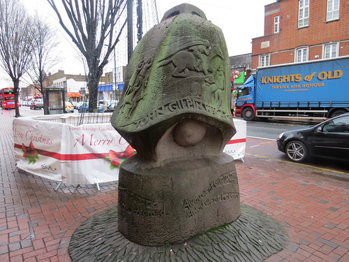
This is called Gilpin’s Bell and is by Angela Godfrey and dates from 1996. It was inspired by a comic ballad from 1782 by William Cowper, entitled “The Diverting History of John Gilpin”.

This is the story of Gilpin and his wife and children on a journey to the Bell Inn, Edmonton. They become separated after Gilpin loses control of his horse, and is carried ten miles farther to the town of Ware. And much the same thing happens on his return when he is carried past Edmonton back to the City.

As an entertainment, this does seem rather tame by today’s standards. And the sculpture itself is not that well located and it seems to be getting a bit weathered but maybe that was the intention.

Retrace your steps along Fore Street.

If you want to keep going and you can see the Wetherspoons pub, Gilpin’s Bell which also celebrates the story and is close to the site of the old Bell pub which was demolished in 1963.

IMG_6166

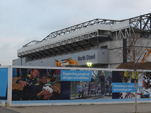
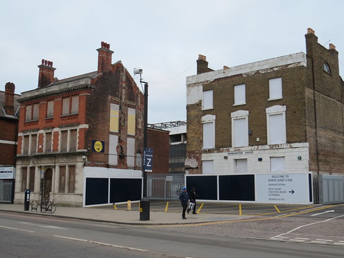
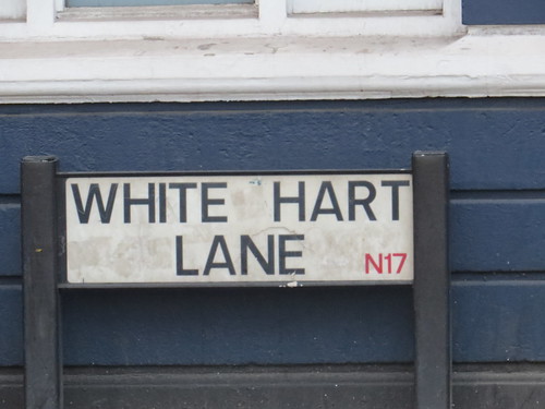
By the way this pub is on the border with Tottenham, not so far from White Hart Lane football ground and it seems that on match days entry to this pub is restricted to home supporters. So beware if you are here on a match day and are not a home supporter, because you will not get in. But then again why would you volunteer to go anywhere near a major football ground on a match day unless you were actually going there.

If you do not want to take this short detour, turn right into the side street between the White Horse pub and Corals bookmakers. Otherwise return back to this point on Fore Street and turn left.

Go ahead into Joyce Avenue, going through the housing estate and you will see a slope leading up to a bridge over the railway.

IMG_6160

Go over that bridge. Our next stop is just on the other side.

Stop 2: Javier’s memorial

IMG_6159

IMG_6157

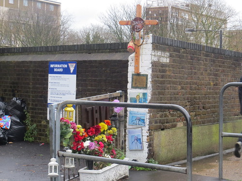
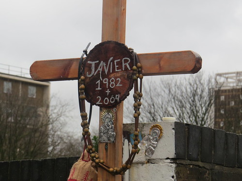
I have no idea who Javier was or why he is memorialised here. My Google searches have thrown up nothing. One can only assume he died on the railway just here. The memorial has been here some years and perhaps predates the time when people obsessively published material on the Facebook and elsewhere on the internet.

It is also an unusual survivor. Normally these roadside shrines are removed by the council after some months. But this one has survived presumably because it is in a no man’s land between the council’s highway land and railway land.

Go straight ahead along Bridport Road. Our next stop soon sprawls out all along the right hand side of the road.

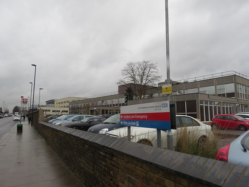
Stop 3: North Middlesex hospital

This site was originally Edmonton workhouse in 1842. A separate hospital building was opened in 1910. It became a military hospital in 1915, known as Edmonton Military Hospital. Once back in civilian hands in 1920, the hospital became known as the North Middlesex Hospital – or the North Mid. It is the main hospital for this part of North London.

IMG_6155

IMG_6152

Walk along Bridport Road and turn right into Bull Lane. As you approach the North Circular Road you will see a subway on your left. Use this to cross the main road. Once on the other side, keep going. This is Tanner’s End Lane. At the end of this street turn left and our next stop is a short distance on the left.

Stop 4: Millfield House and Arts Centre

Go through the gate and ahead to the left is the old house, dating from 1796.

IMG_6151

Although owned by John Wigston of nearby Trent Park, it was initially let to the Imperial Ambassador of the German Empire. Later (in 1849) it became a school for children of the Strand Union Workhouse children. The Strand Union Workhouse was based in the City of Westminster, but ended up setting up an outpost here next door to the Edmonton Workhouse.

There is a fascinating website called  http://www.workhouses.org.uk which gives a lot of information about the Strand Union and Edmonton Workhouses http://www.workhouses.org.uk/Strand/ and http://www.workhouses.org.uk/Edmonton/

It became a hospital in 1915 and was converted to become an Arts Centre in the 1970s, based in the house.

IMG_6148

A purpose built theatre and library was opened on the site in 1988. The library relocated to Fore Street in December 2008 and the building was redeveloped as a cafe bar and performance space.

IMG_6146

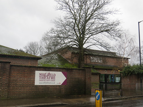
The theatre was reopened in October 2009 by local boy Sir Bruce Forsyth after whom the main auditorium was renamed.

If you have ventured into the site go back to Silver Street and just along from the car entrance you will see a street (Windmill Road) across the road with a school at the corner. This is the Aylward Academy, named after Gladys Aylward, more of whom anon..

IMG_6142

Go down Windmill Road and take the third turning on the right. Our next stop is a little way along on the right.

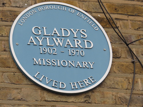
Stop 5: Number 67 Cheddington Road

IMG_6138

Number 67 was the home of Gladys Aylward (1902 – 1970) who was a Christian missionary to China.

IMG_6139

Her story was told in the book The Small Woman, by Alan Burgess, published in 1957, and made into the film The Inn of the Sixth Happiness, starring Ingrid Bergman, in 1958. The movie was produced by Twentieth Century Fox, and filmed entirely in North Wales and England (!) with most of the chinese children in the film coming from Liverpool where there was a sizable chinese population.

Apparently Aylward was not happy with her depiction in the film. Whilst she was small in stature with dark hair and a London accent, she was played in the movie by the tall Swedish actress Ingrid Bergman. And the story was romanticised. And one of the chinese characters (the mandarin of the town in which Aylward lived) was played by Robert Donat, who was most definitely not chinese. This was his last movie – he died before the film was released. We saw his blue plaque in NW11.

Intriguingly, the establishment of the film’s title was actually called the Inn of the Eight Happinesses – eight being an auspicious number in China and there being eight desirable attributes: Love, Virtue, Gentleness, Tolerance, Loyalty, Truth, Beauty, and Devotion. But for some reason the film version called it the Inn of the Sixth Happiness.

Continue walking along Cheddington Road. At the end do a right then an immediate left into Park Lane. Take the fourth turning on the right (Sweet Briar Walk). This goes alongside Pymmes Park. As the road takes a turn to the right there is an entrance to the park go in here. Follow the path with the lake to your left.
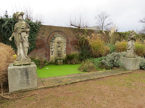
Stop 6: Pymmes Park

IMG_6137

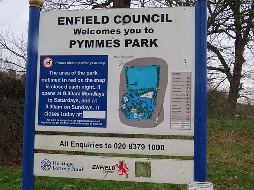
Pymmes Park originated as a private estate. In the late 16th century it was owned by the powerful Cecil family. In 1589 Robert Cecil, later 1st Earl of Salisbury, spent his honeymoon at Pymmes. The estate was eventually acquired by Edmonton Council and opened as a public park in 1906. Pymmes House was destroyed by fire in the 1940s and the remains were demolished.

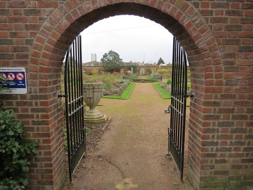
There is a rather nice walled garden, though it is sadly marred by the noise of the nearby North Circular Road. You find this by searching out the Visitors Centre which is rather strange looking white building that looks like it has escaped from an army camp.

IMG_6134

If you go to the right of this, you will find an archway that leads into the walled garden.

IMG_6130

IMG_6131

IMG_6133

Head back round the Visitors Centre and go out on to Silver Street.

Ahead you should see the railway on an embankment and some steps going up to Silver Street station, our next stop.

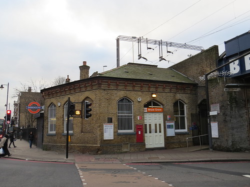
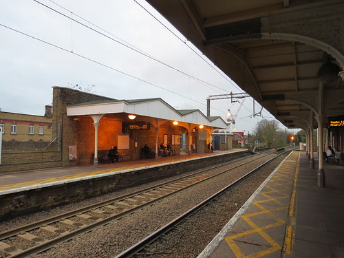
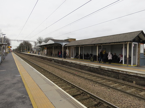
Stop 7: Silver Street Station

This is the next station after White Hart Lane going out of London. Built in 1872 and like the other stations we saw in N15, N16 and N17, it has those unattractive unroofed stairs. It should perhaps have been called Upper Edmonton, but was not.

IMG_6127

The London bound platform retains its canopy, although altered and strangely extended. The country bound platform has lost any covering it might have had.

IMG_6123

Back down to street level, go under the railway and continue to the junction. Although you cannot see it you are standing on top of the North Circular Road which at this point has been tunnelled. Our next stop is at the corner of Fore Street.

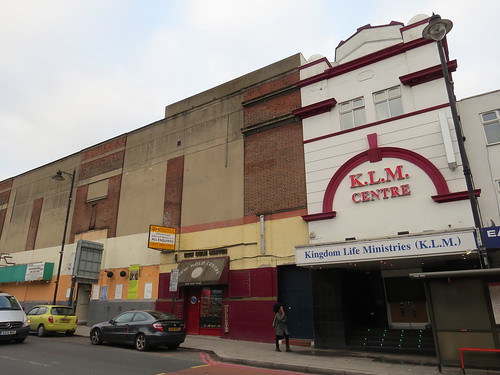
Stop 8: Site of Regal Cinema

There is a ghost of a sign to hint at what was once here.

IMG_4720

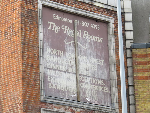
This was the location of a huge cinema called the Regal. Opened in March 1934, it seated almost 3,000 people and had full stage facilities. It also contained a restaurant and ballroom, which each had their own separate entrances.

According to the wonderful Cinema Treasures site, the building was owned by the Abrahams family, but it was initially operated by the Hyams & Gale circuit. They were taken over by Gaumont in October 1935. Eventually Gaumont became part of the Rank Organisation but always the building was owned by the Abrahams family who installed clauses in the lease that it should always remain fully equipped as a cinema with full working stage facilities.

The stage was used less frequently as years went by, but still packed them in when artists such as The Beatles and Frank Sinatra appeared.

The cinema closed in July 1972 but it was reconfigured with the stalls seating removed and the floor levelled, becoming a disco and live concert venue named the Sundown. Groups such as Hawkwind, Doctor John, Steppenwolf and The Groundhogs played this venue.

However, this venture lasted less than two years and in March 1974 it reopened as the Regal Cinema, using seating that had remained in the circle. This was also not successful lasting only until August 1974.

The Regal Cinema became a Top Rank Bingo Club. Bingo lasted until 1985 when planning permission was granted for demolition which happened during November/December 1985.

Right up to the end, the Rank Organisation had honoured the lease and kept all equipment in the theatre to full working order. Cinema Treasures says that projectors were well oiled and run on a weekly basis just in case films returned, the stage revolve, curtains and screen were all there, even the organ which was often still used at well attended concerts and to entertain the bingo players was in immaculate condition when the bulldozers moved in.

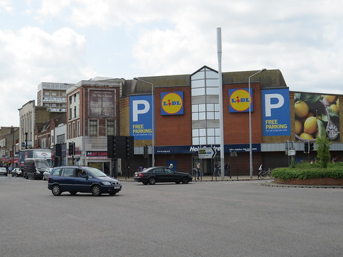
A Safeway supermarket was built on the site which is today a Lidl supermarket.

IMG_4716

Now with your back to the supermarket go up Fore Street, crossing the side street. Our next stop is ahead on the right.
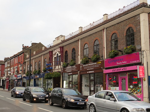
Stop 9: Angel Place

This is a interesting survival – a terrace originally dating from around 1730 which were altered in the middle of the 19th century. Now Grade II* listed buildings.

IMG_4723

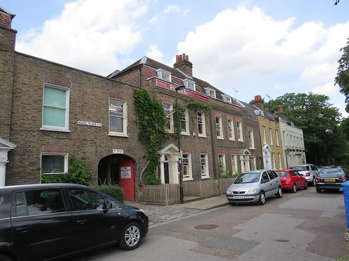
185, 187 and 189 were extensively restored in the 1980s to include the formation of an arch at 187 Angel Place with gardens behind.

Set back from Fore Street, the buildings were adjacent to The Angel public house. But today there is no Angel. The Angel was demolished to widen the North Circular Road, but which cannot now be seen as previously mentioned this road is below us in a tunnel..

IMG_4722

Continue along Fore Street

Stop 10: site of Alcazar cinema

Just a little way along is a 1960s block of shops and flats and guess what, this was the site of an old cinema.

IMG_4713

The Alcazar Cinematograph Theatre opened in June 1913 as part of an entertainment complex which included an enclosed Winter Gardens, which had a palm court and provision for dancing, and an outdoor Summer Gardens as well as a roller skating rink and a tea room. The building was designed like a Moorish palace, with a covered veranda stretching 140 feet along the facade at first floor level.

According to Cinema Treasures, demand for seats at the opening was so great, that the 1,700 seat cinema was filled to capacity and seating had to be placed in the Winter Gardens to take the overflow. It became a regular occurrence to screen popular films in both spaces, and in summer months, the Summer Gardens were also used as a cinema.

The Alcazar was rebuilt in 1933 and was the last cinema in the area to be fitted with sound equipment. It suffered badly when the new giant Regal Cinema opened in March 1934 just up the road on Angel Corner.

The Alcazar closed when it was hit by German bombs on 23 August 1940. This destroyed the dance hall and one wall of the cinema, causing the roof of the auditorium to cave in. Further damage was done by a V1 flying rocket which landed nearby in October 1944.

The remains were demolished and the site stood derelict until the 1960s, when the council built a small parade of shops with flats above, and houses at the rear on the site of the Summer Garden.Today a British Red Cross Charity Shop is located where the entrance to the Alcazar Picture Theatre once was.

Strange to think that for a brief period of around 30 years there was this exotic building here in Upper Edmonton. And one wonders if it had not been destroyed by enemy action as to whether it might have survived til today.

Well that brings us to the end of our N18 walk. We have seen a rather odd sculpture (and pub) reminding us of an obscure 18th century song, we have heard about a missionary and how her life story was treated by the movie industry. and we have seen the sites of two old cinemas, where today there are just ordinary workaday buildings. I thought N18 had little promise when I started but like many of these outer areas there are still some interesting nuggets to reveal.

https://www.eventbrite.co.uk/e/merton-park-the-little-known-garden-suburb-tickets-12396639683?ref=ebapihttps://www.eventbrite.co.uk/e/merton-park-the-little-known-garden-suburb-tickets-12396639683?ref=ebapiFor onward  travel you could return to Silver Street station or there are plenty of buses along Fore Street.


N17: Spurred into action

N17 is Tottenham proper as opposed to South Tottenham, or Seven Sisters which we saw in N15. And of course Tottenham is forever associated with Tottenham Hotspur Football team.

We start our walk at the Bruce Grove Post Office at 476 High Road, N17 9JF.

Turn left out of the Post Office and continue along the High Road past the Police Station. Our first couple of stops are just opposite the Police Station

Stop 1: Former Palace Theatre, 421 – 427 High Road

IMG_6004

This building looks like an old theatre and indeed it is. This was built as the Palace Theatre of Varieties, which opened on 31 August 1908. And the date can be seen in the ironwork on some of the doors. If you look carefully, you can see “19” in the middle of the left panel and “08” on the right.

IMG_6001

For the first few years, it was presenting a mix of variety and drama but in 1922 it began showing films in the afternoons some days a week. From November 1924 it became a full time cinema, renamed the Canadian Cinema.

According to the wonderful Cinema Treasures site, it would most likely be at this period of time that the projection box was built on the rear of the stage and this theatre remained a back-projection cinema for the rest of its life – a somewhat unusual arrangement. The reason for this was there was no room available in the rear of the dress circle and one in the rear of the balcony would have given too steep an angle and a keystone effect on the screen.

It became the Palace Theatre once again in January 1926 and was taken over by the Gaumont British Theatres in 1929.  Gaumont merged with Odeon later and they became part of the Rank Organisation. Rank closed the Palace Theatre on 28 June 1969. It does not seem to have been renamed either Gaumont or Odeon at any time.

The building was converted into a Bingo Club, initially operated by Mecca and later by the smaller chain of Jasmine Bingo Clubs. The Jasmine Bingo Club closed in February 1996. The building became a church initially called the Palace Cathedral, but now is something else.

Our next stop is literally next door.

Stop 2: site of Royal Ballroom, 415 – 419 High Road

IMG_6006

This modern building was once the location of the Royal Ballroom.

The first entertainment building here was a roller skating rink which opened in February 1910. Clearly the roller skating craze quickly waned because the building was soon redesigned opening as the Canadian Rink Cinema in June 1911. By 1925 it had closed as a cinema, possibly due to the adjacent Palace Theatre converting to full time cinema use (and taking the name Canadian Cinema for a while – see above).

According to Cinema Treasures, the Canadian Rink Cinema was converted into a dance hall known as the Tottenham Palais and became a well known North London nightspot for several decades. Later owned by Mecca, by the 1960s it was known as the Tottenham Royal and in later years became the Temple nightclub. It was demolished in 2004 and this modern building is now on the site, leaving no trace of the fact this was once a place of entertainment.

Walk a little further along the High Road and turn right into Drapers Road. Our next stop is ahead beyond the gates.

Stop 3: Old School Court

Today this is called Old School Court.

IMG_6008

But as the sign explains this was built as Drapers College.

IMG_6010

The sign says it was established by the Worshipful Company of Drapers in 1858, but architectural historian Pevsner dates the building to 1860- 1862. It was Tottenham High School for Girls from 1885 to 1985 and the building were converted to residential use in 1996.

Return to the main road and back towards where you started.

This is by the way the old Roman road Ermine Street which comes out of the City at Bishopsgate and heads north to Lincoln and York. Ermine Street is an old English name, as no one knows what the Romans called the road. But it has nothing to do with the fur Ermine but rather derives from the name of a tribe called Ernigas whose territory the road ran through in Hertfordshire and Cambridgeshire.

Soon on the left you will see the main road (A10) takes a left turn under a railway bridge, the line of the old roman road carries straight on. Our next stop is here at this junction.

Stop 4: Bruce Grove station

IMG_6021

Although Bruce Grove station seems to be better preserved than Stoke Newington, it too has had its staircases denuded of their roofs. I do think this looks horrible but no doubt it is cheaper to maintain.

IMG_6019

But if you go up to the platform, their canopies seems to have survived in their original form, including their wooden fascia boards.

IMG_6017

However according to Wikipedia all is not what it seems. In the early 1980s several changes were made to the appearance of the station, apart from the staircases. The London bound platform roof was shortened and the waiting rooms boarded up. The North-bound roof opposite (which was identical) was completely removed and a small brick shelter was installed in its place. This shelter lasted for nearly twenty years before it was itself demolished and a new roof, built in the style of the original though much shorter, was constructed giving the illusion of original authenticity to the station. Haringey Council funded this work and the station is considered a site of historic interest in the locality.

Return to the street and turn left under the railway. Our next stop is just ahead on the right.

Stop 5: former Bruce Grove Cinema, 117 Bruce Grove

Here we have another old cinema.

IMG_6024

The cinema here first opened in July 1921 and was operated by a local independent company, Tottenham Cinema and Entertainment Co. Ltd, according to the Cinema Treasures site.

The building was reconstructed in August and September 1933. Externally it was modernised and the original domed tower feature was removed. The auditorium was Art Deco style.

In 1962 the cinema was taken over the Star Cinemas Ltd of Leeds who closed it in August 1963 and converted it into a Star Bingo Club. At some time the building was spilt with the stalls area becoming a snooker club and the former balcony extended forward to the proscenium to remain a bingo club for a few more years.

Bingo upstairs closed in May 1983 and the space was empty until 1986. It was used for two short lived ventures (an indoor cricket pavilion and a “Quazar” laser shooting gallery). Then in the early 1990s it was converted into a church, known as the Freedom’s Ark. Snooker continued in the former stalls area, together with a Caribbean restaurant.

In May 2011, the Freedom’s Ark church vacated the building and moved elsewhere in Tottenham. But there seems to be a church in here again now but I am not sure what the rest of the whole building is being used for.

Our next stop is just next door

Stop 6: Former Bruce Grove Ballroom, 113 Bruce Grove

IMG_6029

In 1923, the owners of the Bruce Grove cinema commissioned the cinema’s architect (Charles E. Blackbourn) to design a ballroom, to add to the cinema’s amenities.

It opened in 1923 as the Bruce Grove Ballroom, with the ballroom upstairs at first floor level, and shops on the ground floor.

The Star Cinemas chain seems to have acquired this at the same time as the cinema and continued to operate the ballroom until 1974, when they converted it into a four-screen cinema, opening in July 1974 as Studios 5,6,7,8 – not sure where Studios 1, 2 3 or 4 were. These operated until December 1981. The building was then empty for a couple of years until it was returned to a single space and reopened as the Regency Banqueting Suite in 1984, which is what it is today.

Now look across the road.

Stop 7: Number 7 Bruce Grove

We are stopping at Number 7 not because of the building but because of who lived here.

IMG_6031

IMG_6026

Luke Howard (1772 – 1864) was an amateur meteorologist. As the blue plaque delightfully says he was a namer of clouds. He was not the first to try to name clouds – a Frenchman, Jean-Baptiste Lamarck (1744–1829), beat him to it but it was in French. Howard’s system used Latin and applied the principles of natural history classification, as espoused by Carl Linnaeus. Thus Howard arrived at a workable solution to the problem of naming transitional forms in nature, like clouds.

Continue walking along Bruce Grove. Our next stop is ahead on the right.

Stop 8: Drapers Almhouses

Continue along Bruce Grove and our next stop is set back off to the right of the street. These were built in 1870 by three foundations connected to the Drapers Company.

IMG_6039

As the sign says they were modernised during the years 1978 – 1981.

IMG_6035

So although the Drapers do not seem to have a school in the area now, they still maintain the connection to the area with these almshouses.

Continue to the end of the road and our next stop is immediately ahead beyond the mini roundabout.

Stop 9: Bruce Castle

This is the somewhat misnamed Bruce Castle, as it is not and never has been a castle.

IMG_6043

The name Bruce Castle is derived from the Scottish House of Bruce, who way back had owned a third of the manor of Tottenham. When Robert the Bruce became King of Scotland in 1306 he forfeited his lands in England, including the Bruce holdings in Tottenham, ending the connection between the Bruce family and the area.

The three parts of the manor of Tottenham were united in the early 15th century under the Gedeney family.

The front we see today from the road dates from a remodelling of the house in the late 17th century, but with some additions were made in the 18th century, but there may be some older bits lurking.

Bruce Castle is now a museum, holding the archives of the London Borough of Haringey, and housing a permanent exhibition on Haringey and its predecessor boroughs, plus temporary displays on the history of the area. There is also an exhibition on Rowland Hill and postal history – Rowland Hill was the instigator of the universal penny post and his connection to Bruce Castle is that he lived here in the 1840s.

It s worth a quick turn if it is open as you pass.

Behind the “castle” is a park which was the first public park in Tottenham, opening in 1892.

Now take Church Lane which the road running down the left hand side of the “castle” and park. Pass the Church and our next stop is as the road bends to the right.

Stop 10: Prospect Place

IMG_6060

Here we have a lovely little terrace of houses dating from 1822 and called “Prospect Place”.

IMG_6059

And this is the prospect today:

IMG_6055

If you have time you can venture into the cemetery and see the river Moselle, one of the London almost lost rivers, which we heard about in Muswell Hill.

My fellow guide, Jen Pedler has created a walk which follows the path of the Moselle. This was first done as part of the Footprints of London River Walks festival in Spring 2015.

When walking through Tottenham which was perhaps not the most scenic part, Jen got her walkers to join in a 400 year old song, called “The Tottenham Toad”. This is about the courtship of a Tottenham lad (‘toad’), who falls for a country girl from Enfield (‘squirrel’), But the river Moselle keeps flooding its banks forcing him the wade through high waters to make it work.

Here are the words:

The Tottenham Toad came walking up the road,
With his feet swimming in the sea,
‘Pretty little squirrel with her tail in a curl,
They’ve all got a wife, but me.’
I married me a wife to join my life,
She soon wished I were dead.
In about six weeks we had a little quarrel
And she pulled all the hair out of my head.

Sadly I do not have Jen and her walkers singing this. But here are two local schools (Noel Park and St Francis De Sales) with their version (which does not exactly follow the above words).

http://www.ariver-runsthroughit.org.uk/events/singing-tottenham-toad-bruce-castle

Continue along the road (which is Church Road) and at the end you will be back at the High Road.

Stop 11: Tottenham Hotspur (“Spurs”) Football Ground (White Hart Lane)

You cannot really miss our next stop as it looms up over the main road.

IMG_6083

Known as White Hart Lane, the curious thing about it is that the ground is not actually in White Hart Lane.

IMG_6069

Tottenham Hotspur Football Club can trace their origins back to 1882 and they started playing at this site in 1899. The name “Hotspur” is said to be is a reference to Henry Percy, whose descendants owned land in the neighbourhood of the club’s first ground in the Tottenham Marshes. Henry Percy is remembered largely because he is a character in William Shakespeare’s Henry IV, Part 1. Percy is killed by his rival (and the future King), Prince Hal. Henry Percy was also known as Harry Hotspur as he wore riding spurs and his fighting cocks were fitted with spurs. The latter can be seen in the crest used by the Football Club.

Today the ground is undergoing a multi-million pound rebuild.

IMG_6077

In the past the club did consider relocation. Back in 2001, there was the idea of relocation to a proposed 43,000-seat stadium at Pickett’s Lock. This would have been built for the 2005 World Athletics Championships. However the games went elsewhere and so the stadium was never built. Other possible relocation included the new Wembley Stadium and the 2012 Olympic stadium. In 2013 the latter stadium became the subject of fierce competition between Spurs and West Ham United. West Ham won although the decision was initially challenged by Tottenham Hotspur.

At the same time as the Olympic Park bid, and instead of relocating, the Club was pursuing via its Northumberland Development Project a plan to build a new stadium, partly on the site of the existing White Hart Lane ground. The new stadium has a planned capacity for 61,000 spectators.

Now we let’s go down the actual White Hart Lane which is a side street on the other side of the High Road from the actual stadium.

IMG_6086

Our final stop is a little way down White Hart Lane.

Stop 12: White Hart Lane station

This is the closest station to the Football Ground. It has a modern building at ground level, denuded staircases and some canopies on the platforms, although these are not so well preserved as the ones at Bruce Grove, having lost the original decorative fascias.

IMG_6087

IMG_6093

It is interesting to see how three stations (Stoke Newington, Bruce Grove and White Hart Lane, all built at the same time (1872) and in the same style, have fared in the modern world. All of them have been disfigured. Bruce Grove seems to have come out best even though it is not all original.

Well that brings us to the end of our N17 walk. – several places of entertainment, connections with a City Livery Company, a major football club … and the namer of clouds. And we are at a station which has a reasonable train service (usually every 15 minute) for onward travel.